 As shown above, the USGS has posted this excellent composite thermal & aerial of the current lava flow front on their images page, dated July 14th, 2010. “The active flow areas are shown as white and yellow, while older, cooler flows are shown by purple hues.”
As the above thermal composite clearly shows, and USGS/HVO ground crews documented, the surface flow of lava that is advancing onto the coastal flats is just northwest from Kalapana Gardens on the south slopes of Hawaii Island. They also updated their Maps page showing, in red, the present position of the active lava front:
 (Click on the map or images for a larger view size)
USGS’s survey, as of yesterday, reported the leading edges of the two prongs of advancing lava to be less than a mile (1400 meters) from the end of highway 130, which is also the end of the Hawaii County’s visitor viewing area. The flow’s most southeasterly edge is now about one-mile from the ocean.
The speed and direction of this surface flow can be hard to totally predict once lava moves across the coastal flats as it is doing now, but it does appear to still be moving overtop, and parallel to, the recent April-May Quarry flow on the leading edge and east of the Quarry flow on the trailing edge, which, if it continues doing, will place molten lava onto the east end of highway 130 and the forests there. Kalapana Gardens resident’s homes that are built in or on the east edge of this forest have very real concern about that prospect. Many of these homes have only recently been erected in the past few years.
Active lava viewing prospects for the public:
1) Coastal viewing: Hundreds of visitors seeking to witness lava activity have been arriving daily at the Hawaii County Kalapana viewing area. The viewing area is essentially the last mile of paved road on highway 130; the end of which is the same location where lava came onto the highway on May 5th, 2010. A 1/2- mile to 1-mile walk down the road gives views of the lava fuming/degassing where it is coming down the distant pali during the day. After dark, lava glow from the leading edge of this active flow can easily be seen from the road at various points.
Official viewing hours are from 2:00 PM until around 9:30 PM - everyday, with last car allowed in at 8:00 PM. On site are security personnel and a few port-o-potties at both the parking lot and at the end of the road. Vendors occasionally have drinking water and flashlights but it is best to bring both these things with you and also some decent walking shoes. This end of highway 130 is open to all traffic on all other hours.
2) The Halema’uma’u crater has been degassing sulfur dioxide fumes by day and glowing strongly at times after dark from lava deep within the craters pit vent. The broiling molten lava moves up and down inside this massive eruptive vent by a hundred feet at times, in kind of a pistoning action. This raising and lowering of lava has the potential to breach the floor of the crater and might do so in the future. Great views of this impressive crater are from the Jaggar Museum balcony within the Hawaii Volcanoes National Park, depending on the weather; and the park is open to the public 24 hours a day with a nominal entrance fee by day.
-----------------------------------------------------------------------------------------------------
Below are my last three blog posts on this lava flow, which may help show new readers the progression of it
Coastal flats lava continues advancing south and southeast
 Click on any image for a larger view size
Taken last night at 10:00 PM, a star-studded wide-angle view of glowing breakouts of the lava flow as seen from part way down the one-mile highway 130 lava walk. This lower pali section of the surface lava is slowly becoming hidden as it forms top-crusting and tubing; the molten lava then moving underneath. Soon only the coastal flats will have visually strong molten lava, and this may become difficult to see from the Hawaii County designated view road … unless, or until, the eastern front of this flow approaches the remainder of the Quarry Flow kipuka and/or the end of highway 130 itself.
Deflation may slow all surface flow action somewhat.

Below is what could be seen of the current surface flow from the viewing area at the very end of highway 130 as of last night. The cooled lava in the foreground was molten on May 5 & 6th of this year.

Below is my previous two posts: from July 13th and July 10th, 2010:

Inflation pressure returned the past two days, though leveling off this morning, and has energized the entire lava flow coming down the mountain from the TEB eruption site and as of this morning, has reached the coastal flats.
Residents of Kalapana Gardens last night reported a spectacular river-like flow of open surface lava; these rivers were said to be high up on the pali. This flow also has a broad area of breakouts all the way down the east edge of the Pulama Pali, with the most westerly lobes hitting the coastal flats. The most eastern section on the lower pali, nearing the coastal flats, does appear to have the potential of covering more of highway 130 and possibly enter more forest west of, but close to, the Kalapana Gardens area. Deflation/ Inflation cycles may also play a big part of how this plays out in the weeks ahead.
 Thirty-feet long and still hot pahoehoe folding.
The photos above were taken during my hike up the flow edge on July 9th; click on any image to open a larger view size.
 Last nights setting crescent moon
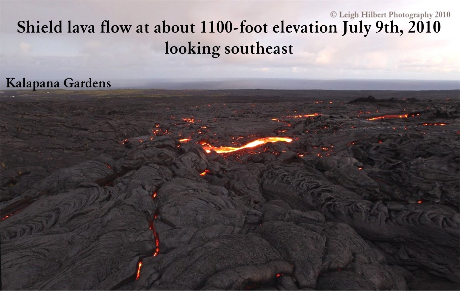 (Click on any image for a larger view size)
I documented the Pulama Pali lava flow the afternoon and evening of July 9th, 2010 by hiking from the coastal flats all the way to the rootless-shield zone - (I am very experienced hiking lava flows; hiking lava is full of real hazards and should definitely not be undertaken by other than those qualified to do so – especially after dark). The big lava surge that ploughed down the mountain the 6th to the 8th has now slowed but continues advancing. Deflation of magma pressure likely caused the slowing, as well as draining of the stored lava within the upper shields.
Below are a few more of the photos I took up on the slopes. This current lava flow is well east of the old Royal Gardens subdivision area and is flowing across the 1986 to 1992 Kalapana Gardens flow fields and within 300-yards of the eastern border of upper kipuka forest.
 Much of the molten lava is rough & jumbly pahoehoe/A`a mix, with some swaths of pahoehoe breakout rivers and toes, as shown below.
 This lava was flowing as open rivers a couple days ago, and was a part of what was seen from highway 130 so spectacularly on July 7th & 8th.
This flow appears to be headed toward the sill warm April-May Quarry flow field on the coastal flats; where it will cross over it. It may then take out the last of the Quarry kipuka and possibly take out some more of the pavement at the end of highway 130, or not… we will know in a few days. This flow is close to pouring onto the coastal flats, and will do so in a day or two, depending on inflation and deflation lava pressures from the eruption site at ‘D’ vent near Kupaianaha, which USGS/HVO monitors currently show the past two days of deflation is now leveling.


No comments:
Post a Comment