Sunday, February 26, 2012

Video of Pulama Pali lava rivers, a`a and pahoehoe

This two-minute video is what I shot on February 24th, 2012, as detailed in yesterday's posting
The gushing rivers are from a rupture in the lava tube feeding the flow front, which is a mile further down the pali from here. Lava is being feed from the Pu`u O`o Crater located four miles to the northwest; Kilauea Volcano's most active eruption source since 1983.
Click on the 'Tube' of YouTube on the bottom right to watch this in larger sizes on their site.

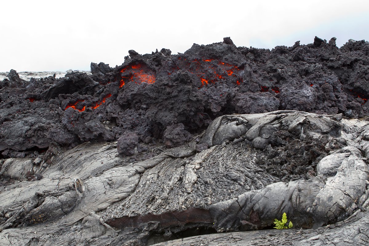
The a`a lava is that rough jagged stuff that crashes itself down the mountain. At the end of the vid are a few slow breaking pahoehoe toes, as they are termed. Those silver-gray lava forms were just cooling and soon after filming they burst alive again as surface lava.
Lava tube rupture forks out the top at rapid speed.

This lava is still over two miles from the open ocean, and does not threaten any homes at this time, though Jack Thompson, whose home is within the tattered fragments of what was once the Royal Gardens subdivision, does have reason to be concerned because there are sprawling breakouts of surface lava above his forest kipuka. It is too early to gauge if that more westerly branch of this large flow field will move down into Jack's area. Forests are burning adjacent to the east, and far above, his place now though.

Saturday, February 25, 2012

Quake swarms and Pulama Pali active with lava flows

I took a break from my lave film editing (See lava movie update below) to trek out onto the flow. Taken yesterday, looking south-southeast from high on the Pulama Pali, about the 1600-ft elevation: these two photos show a very fast moving gusher of lava erupting from the tube system and snaking away as a 25-feet wide river down the pali. In the distance we see some of the coastal plain far below and a cloud-covered ocean beyond. This area is in the top section of the old Royal Gardens subdivision, (as more clearly located in the aerial further down the page)My video of this HERE

~~~~~~~~
These creatively shaped pahoehoe formation (above & below) were taken at about the 800-foot elevation within Royal Gardens on the Pulama Pali. This lava was nearly red-hot and was just recently flowing; the downed trees along the top & edges are still burning. Later, just an hour after I left this area and was hiking the three miles out, I looked back to see a fresh breakout of pahoehoe pouring out over this spot- soon to be followed by a much broader area of breakouts as darkness set in. People at the Hawaii County viewing area could clearly see this show. Click on any image to open them all on a viewer page.

From yesterday: a very cool (&hot) USGS/HVO aerial composite overlay of a thermal and daytime photograph of the Royal Gardens Subdivision area presently being overtaken by branching and widespread surface lava flows. (USGS text in white-- my added notes are in green, yellow & black) -- click on it to read the text better) Active breakouts are shown in yellow, though the thermal imagery exaggerates what is actually flowing openly on the surface, I was there yesterday hiking all over it, as shown in my photos. Read the full thermal caption on their images page.


Below: advancing a`a lava moving across an older lava flow: And closer view:

Below: A ten-foot wide river of lava moving down the Pulama Pali yesterday at the 1400-ft elevation:
Swarms of small earthquakes have been recorded in the past few days. Most of these being concentrated only a few miles west-northwest of Halema’uma’u crater and Hawaii Volcanoes Park headquarters. About five of these were over 3.0 and two were over 4.0 (4.3 early yesterday morning). Keep track of these on the interactive HVO earthquake page here

EDIT TO FLATLINE report: I reported yesterday that the magma pressure graphs had flatlined. I was mistaken because I had not noticed that the radical tilt deformation graph scale had drastically changed to compensate for that long spike down anomaly, therefore giving the impression of being flatlined; I had not noticed the scale change. Thanks to Sagebrusher for alerting me to that oversight. magma pressure deformation tilt monitors

Lava Movie Update:
On the advice of those in the know, I am making two version of the lava movie: one short, around 30 minutes and the other longer at around 45 minutes, which will allow for a broader avenue of distributing it later.

I just completed a nice draft of the shorter one; the longer version raw draft is basically complete. My co-editor I am hiring is unavailable for a while due to another project he is on so I am using my time to continue tweaking the two drafts.

Meanwhile I have written to the music composer’s producer/agent listing the compositions and lengths of the music I want to use for the movie; I am awaiting their reply. Buying the licenses to use these compositions will likely be quite costly, far higher than the editor will be, thus donations to the project are still very much appreciated!! (See Sidebar). Thanks so much to those of you who have so generously joined with me to help get this movie to the next level and out there to the world!!!

Wednesday, February 15, 2012

Kilauea’s Pu`u O`o Crater lava reaches Pulama Pali

USGS/HVO image.

Not since New Years Eve has surface lava been active on the Pulama Pali. It is now only four miles west-northwest of Kalapana Gardens community, and can be seen after dark from that area. Surface flows have been slowly spreading and inflating southeasterly between Pu`u O`o crater and the Big Island’s coastline.

These surface flows, which are mostly pahoehoe, are still nearly three miles from the sea, with the leading flow front located just above the mostly devastated and abandoned Royal Gardens subdivision. This front is moving across, and basically parallel to, and just east of, the last big lava surge we had come through the area last December.

At this time, the active surface lava is not endangering any forests or homes. Magma pressures within the Kilauea pluming system will likely determine when or if this flow front will advance further down the pali towards the sea.

I may go take a close look at this in the days ahead and report back here.

As always, the US Geological Survey (USGS) / Hawaiian Volcano Observatory (HVO) are doing excellent coverage of all eruptive activity around the two craters and surface flows.
Here is their most recent flow field mapping from February 8th – (The surface flows have further advanced since then) –
Below are some specific links to note:

Their Images page has this QuickTime video shot February 8th showing rapidly running lava within a skylight opening and also the flow fields and fuming lava tubes from Pu`u O`o and down slope to near the Pulama Pali. (I find these QuickTime videos load slowly for me—but it might just be that way for my connection speeds)

This HVO field webcam currently shows the main area of surface lava; this is especially evident after dark if there are no rain showers. (Once the link opens you can click on it for a larger view size).

Here is a parting shot taken one year ago today: Sunrise over Kalapana Gardens… my favorite coastal lava shot, or maybe that’s because it was taken on my birthday ;)
Lava Movie update:
First off— I am so appreciative to those of you who have so kindly donated your funds towards the completion of my feature lava movie! You will all receive signed final versions of the movie on DVD and be listed as sponsors within the movie credits.
With those funds I am now arranging to hire a professional co-editor to help fine-comb my rough (but very cool) first drafts, and to add any special affects that may enhance it. I am holding off on bringing in the co-editor a little bit more as I do some important tweaks to the draft and share that with a few friends at a screening here in my home tomorrow night. This will be my third showing of the movie drafts in the past month and the feedback is important; it let’s me know the strengths and weaknesses of the story and footage. This movie is looking sooo good now! (the screeners get excited to come back and see it again - a good sign I think :) It currently has a running time of 45-minutes, which I hope to keep it close to through the editing ahead.

Friday, January 27, 2012

Lava activity confined to Pu’u O`o and Halema’uma’u craters - and - lava movie update

The pink is where it was just weeks ago, the red where the surface breakouts are today.

Surface flows of lava that were flowing down the Pulama Pali (again, the pinkish zones in the flow field map above), and across the coastal plains right into the ocean ended on the last day I was out there, and reported on in my New Years Eve posting.

According to USGS Hawaii Volcanoes Observatory (HVO) updates, there some surface flows 2 miles southwest of Pu`u O`o, and a new shield mound swelling with stored lava, as well as pooling inside the crater. I suspect that one day these shields will rupture and re-introduce lava down the Pulama Pali below.

Inside the Halema’uma’u the broiling lake of lava has risen to within 250-feet, or 80-meters, of the main crater floor rim, and has been exhibiting some more violent activity. One such event was documented last week and now posted on HVO’s images and worth a watch. (Their video is posted below the January 25th heading.)

Toxic sulphur dioxide fume levels have been elevated to as much as 1500 metric tons per day and those volcanic fumes, or vog as it is known as here, have been more often spreading down across the Hawaiian Island chain do to southerly wind patterns lately. In fact it is voggy where I am at now, on Cape Kumukahi; ironically, the lighthouse at the cape is where the air quality for all of America is sampled and considered the base scale for the purest air of all - well not today!

My home shook firmly but briefly earlier in the week from a 4.7 earthquake that was located midway between the Big Islands south shoreline, west of the recent surface flow, and Pu`u O`o. That event was felt far and wide on the island and was followed by something like 57 small aftershocks, the largest being around 3.0 on the magnitude scale. Interestingly, the USGS did not believe these quake clusters were related to any magma movement.

Take a look at the difference a year has made to the extensive lava flow fields from crater to sea, as shown on these HVO maps: Here is the area one year ago-- the January 13th 2011 flow map:
-And the January 26th 2012 flow map I posed at top: Use the Royal Gardens and Kalapana Gardens subdivisions as reference points.

The new lava movie project:

My absence of recent posts has been from both a lack of accessible lava and my complete dedication to my new lava movie.
I am very excited about this video production -- it has finally taken form and I have a pretty tight draft as of now. This movie is really powerful, fast paced and emotionally moving-- It is very near to exactly one hour in length (it would make an excellent TV special on programs like the Discovery Channel and I will be submitting it to TV outlets eventually). Film festivals for sure too.

Where the project goes from here:
I still have some very serious final editing to do, six music tracks to buy license to, and a host of other post-production hurtles to deal with, right up to Full High Definition versions for both screen and top quality DVD’s.

These challenges are all doable but what is stopping me now is funding; I simply can not move forward without help; this movie will stop as a draft on my big hard drives without sponsorship.

*This is where you can join in and become an active part of this lava production!*

--- Anyone that contributes will have the choice to be listed in the credits of the final movie— Donations over various amounts, listed down on the right of the page here, will get other special rewards like you being listed as executive producers or sponsors, receiving signed lava photos and DVD’s, get personal invites to the opening screenings, which I will attend. (The first showing will likely start at our local Palace Theatre here on the Big Island, and then to the US west coast venues).

You wouldn’t be on my site here if you also weren’t also keen on eruptive lava action and the amazing things it does while it is transforming an entire landscape and even dislocating entire communities.
Since the beginning of this blog 2 ½ years ago I have been offering Hawaiian Lava Daily to simply share with you what I am passionate about and blessed to be able do: hike, take lava eruption photos & videos, then post these images and write about it. My site has always been free of advertising because I did not want my offering to be about money, as most internet sites are; I just wanted to share these passions.

If I could, I would certainly complete this film on my own, but I can’t. So if you have enjoyed my postings, lava photos and videos, you can now share in both my passion for lava and in helping to get this super-cool lava movie out in to the world for all to enjoy. There are a few different ways you can donate; I explain them within my plea that is all down along the right of this page.

And mahalo nui loa (a big thank you) to those of you that have already chipped in!! This movie will get done yet! My goal is to have the hurdles past us and to be showing the movie and sending out DVD’s by this summer.

Saturday, December 31, 2011

Pulama Pali lava flow today ~and~ 2011 lava flow, year in review

Above: Pulama Pali lava breakout and sky taken late last night with a 15mm fisheye lens (click on it for large size)

I hiked to Royal Gardens subdivision, or the tattered remains of it, and talked with Jack Thompson. Above is his beautiful hand-built home, taken from the same spot as the view looking down his road remnant that leads to the active lava flow 350-feet away, and an ever present tour helicopter over the fuming lava.
And here, below, is what we can see of Jack's house from the other side of the hot lava flow at sunset last night. The lava is inside tubes and heading down to the sea. Jack's home is hard to see, but it is in the distance nearly hidden in the trees on the left, and is the same location I filmed that flow at its peak (that blog post here)

This December lava flow has just slowed down after covering miles of the coastal plains and pouring into the ocean, but late last night I witnessed an new large breakout of a`a lava on the top section of Royal Gardens about 2000 feet above Jack's house. Below is a photo of the Pulama Pali I took today with my notes indicating significant places and dates: Click on any image to open them all in larger viewer window.

~~~~~~~~~~~~~~~~~~~~~~~~~~~~~~~~~~~~~~~~~~~~~~~~~~~~~~~~~~~~
LAVA YEAR IN REVIEW, 2011:
January: Some of JANUARY 2011 highlights You can scroll down them all at once, but not all of January will show. We also lost a home to lava on the 18th.(house frame in upper left and circled in notes on aerial below:

February 2011provided some wonderful photo opportunities to me with some active surface flows: FEBRUARY postings

MARCH 2011 : On March 5th That day was the last coastal plains lava flow until the recent December Royal Gardens flow currently happening. That same day we had a major floor collapse within the Pu`u O`o Crater. Lack of acceable lava caused my blog postings to become very slim in the months following, but there were some reports:
April 2011
In June the action was inside the Pu`u O`o Crater as it also was in July & August. On August 4th, the crater floor collapsed again, spilling out volumes of molten lava fissures from its flanks.
This continued slowly expanding through SEPTEMBER, OCTOBER, NOVEMBER
And leading, finally, to the spectacular arrival of molten lava rivers down the Pulama Pali December 4th. spilling across the coastal flats at a rapid speed, and pouring into the ocean. All recorded on my five DECEMBER posts HERE

Thanks for dropping by my blog, it has been fun to share this ongoing Kilauea Volcano eruption with you,
All the best in 2012,
Aloha,
Leigh
-Oh, and this is my self portrait taken today, December 31st, 2011-- The Earth according to Leigh ;)

Sunday, December 18, 2011

Lava continues dropping off cliffs into the sea in Hawaii Volcanoes National Park

Dawn at the ocean entry December 17, 2011

The volume of surface lava being sent from fissures at Pu`u O`o Crater through insulating tube systems seven miles south to the ocean changes daily. Yesterday I went by boat to witness this. Another long time lava enthusiast, Shane Turpin took me out on his infamous Lavakai charter boat (his link below) in the predawn light. On this page I will share a few of the images I took as well as a short 1-minute 45-second video of the scene.

VIDEO: shooting movies from a boat without any stabilization can tend to roll around a bit … so I kept it short so you won't get seasick :)

For more information about Captain Shane Turpin and his Big Island boat charter options, unique history and photos, check out his online site See Lava


Here are some more of the photos I took: [Click on any photo to open them all as a set of larger images]


You can see more images taken on this day, and last week, as a slideshow, or any other viewing option you desire, here on my new: Royal Gardens flow flow 2011-2012 online gallery.

My last two posts will show where this lava was last week: Coastal plains lava And the massive lava rivers running through Royal Gardens on the hillsides of the Pulama Pali.

Sunday, December 11, 2011

Royal Gardens lava flow reaches the ocean 2-miles south

Image- Royal Gardens lava fires in the distance as molten lava reaches the shoreline.

At 6:15 in the afternoon of December 9th, lava from Pu`u O`o craters ongoing eruption began flowing into the ocean about two miles south of the old Royal Gardens subdivision. This is our first ocean entry since last February (2011), and also this time it is within the Hawaii Volcanoes National Park - although very inaccessible to the public.

I spent an afternoon out there and snapped these pictures (above and more further down) and also took some video of the pahoehoe doing all it's neat surface flow tricks. Here is a 2 1/2 minute collection of those clips:VIDEO

I was tempted to stay and watch it pour into the sea, but chose to leave and hike back with the last daylight. Two other photographers, Philip and Michael, stayed behind and got some great photos & vids too. It was Phil that later notified me of the official ocean entry time. You can view his great video of when the lava first dripped off the cliffs into the sea (we had been trying to guess) - Here is Philip Ong's video

He also had sneakily snapped a shot of me all splayed out on the lava taking videos, as seen below: Yeah-- I dress pretty covered up for getting close to a volcano goddess at work…
But I also snuck a shot of Philip guessing how long the lava would take to reach the sea...

I love all the endlessly crazy shapes this stuff can create! - Pele's handiwork as they say around here.>

In the days ahead we will find out if this flow will establish itself thru insulating tube systems, or be severed of lava by a plumbing system collapse, or possibly stop flowing due to a large, or sustained drop in magma pressures beneath Kilauea Volcano and the Pu`u O`o crater a little over seven miles uphill to the north. (You can always follow their daily updates here)

A few hardy souls made it to the leading edge of the lava streams. (CLICK ON ANY IMAGE HERE TO OPEN THEM ALL LARGE)

Below: Royal Gardens as seen from the coastal flats -- Jack Thompson's house, the reddish square near the middle of the forest and left of the dense smoke, has survived this flow so far-- as it should be! This is also the exact location of where I filmed those wild lava rivers!

**** So this will be my last report on the new flow for awhile. I do not plan to make regular trips across many miles of old, raw & wild lava fields just to check on this newly established ocean entry. But I will report any substantial changes to it.
>>> I am also working an a serious feature lava flow movie -- The story is nearly formed-- tons of hynotizing molten lava footage, edited and ready to go! -- Hey, if any of you know of a movie producer, or someone willing to finance this movie, please email me. I am also hoping to get certain well known composer (already picked) to lay the soundtrack -- but need help to do that too. Thanks for any suggestions! ****


~~~~~~~~~~~~~~~~~~~~~~~~~~~~~~~~~~~~~~~~~~~
Public lava viewing options:
The Kalapana Gardens Civil Defense Lava Viewing Area is still operating daily from 2PM to about 9PM at the very end of Highway 130. As of this writing: by day the distant Royal Gardens lava fumes and smoke from burning brush and trees can still be seen, and by night some red-orange lava glow is visible there too. But unless there are new breakouts on that pali, this view of the active eruption may fade from sight in the days ahead. Even the ocean entry steam plume will be too far away to be seen on most days, assuming it continues being feed by lava there.

There may also be views of the lava on the coastal plains from the lower section of the Chain of Craters Road, in the national park, some 4 1/2 miles away from the active lava.

Also, I believe there are one or two die-hard lava tour outfits still offering to take fit individuals the nearly seven-mile roundtrip lavascape hike the new ocean entry. Ask around in Kalapana