Thursday, January 27, 2011

~ Small ocean entry – numerous small surface flows ~

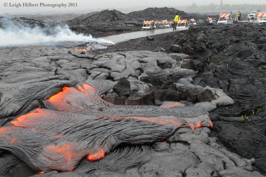
As shown in the photos above and below, lava continues random surface breakouts on the coast. (All photos were taken this morning - click on them for a bit larger view size)

A single small ocean entry continues:

The more westerly lobe of lava, and its weak ocean entry of past weeks, appears to have ceased altogether, although I did not hike to it, I could not see any steam there.

Inland further there are scattered and meandering surface flows continuing to burn off the remaining brush.

Below: Closer to the Kalapana Gardens subdivision, and the present terminus of highway 130 lava viewing site, the area remains quite hot but now has only some very small surface lava breaks. No homes appeared to be threatened at this time.

I will post new updates when conditions on the coastal plain have changed.

Monday, January 24, 2011

~ Aftermath as lava continues moving and inflating near Kalapana Gardens ~

Molten lava continues inflating and breaking out on the surface near the sad and grim remains of a home and property lost to lava January 18th this month.

Here we can see the extent of lava inflation below the homes metal framed ribs – a disturbing aftermath revealing the all-destructive potential of advancing lava. Lava is still molten beneath the new layers.

In my last update I posted the photo below a few days ago showing lava pouring between two metal posts that recently were the entrance to Keone lane, which led into several properties, one of them being the home that was destroyed by lava. The photo below I took this morning and we can now see only the top of one of the posts, the inflating lava has risen that much.

Below: That barbecue I showed in my last post remains embedded on top of the inflated lava just off the end of the highway and the County Lava Viewing Site. Kalapana Gardens homes are perched along the horizon.

Lava continues actively breaking out from the inflating mounds and is filling low areas:


I could not see any pronounced steam from where lava might be entering the sea at either of the two weak entries of a few days ago; just a few brush fires near to the coast.

Friday, January 21, 2011

~ Two weak ocean entries and strong surface flows ~

Shown above and in the photos below, the largest and hottest flowing lava was right off the end of highway 130 yesterday; flowing vigorously between two posts that were the entrance to several properties beyond, including the home recently lost to lava (The shell of that home can be seen in the distant middle-right in the larger view size)

As the lava rivers came near the highway, only a handmade sign defining what a ‘Lavatic Fringer’ is remained next to the side access road that had led to the home lost to lava. Below is the sign as it was before, and the house still standing in the distance. These signs were created by the owner of the nearby property and I was told, were to get people to think, especially lava watching visitors.


Above: Two hours later, in the pouring rain, we can see how inflated and advanced the lava is by using those entrance gate pipes as a guide. ( I can not explain the barbecue sitting on top the inflating lava)By 2:00 PM the Janguard lava viewing security personnel had arrived and were repositioning the barricades for the night.


Meanwhile down along the shoreline I found molten lava dribbling off the cliffs to the ocean.This was all that remains of the western lobe ocean entry from weeks ago.


Below- Eastern entry: At 1:30 PM yesterday lava was also advancing to within 25-feet of the ocean much further east and out over the west end of the July25-Dec 1st lava delta, right off the old Ulua fisherman’s road and where I filmed that lava delta collapse November 2nd . I would assume lava would be meeting the ocean by today, even yesterday large waves were splashing on the molten lava at times creating steam. Judging by the lava volume and movement, this would likely also be a very weak ocean entry unless some more thrust from the supply system finds this area.

Speaking of the supply system, the first pronounced deflation in some time is being recorded by the Kilauea Summit and Pu`u O`o radial tilt meters:

USGS/HVO has posted some new photos and information on their images page They have some great shots of the Pu`u O`o crater lava activity, including a forming spatter cone on the crater floor – click on the link above and check it out.

Below are two images from the USGS images page that I have added a few notes to, showing where the photos of lava I post above were taken and other landmarks in the field.Click on these photos for a nice large size


I will not likely be posting any new updates until early next week, unless something radically changes on the coastal plains lava flow.

Hawaii County Civil defense continues a seven days per week public lava-viewing site that is managed by Janguard Security off the very end of Highway 130 in Kalapana Gardens vicinity. You can get on site updates by calling after 2:00 PM until 10:00 PM daily: 430-1966, or the main hotline: 961-8093

Wednesday, January 19, 2011

~ Very high surf, thunderstorms and lava ~

Besides a flash flood and winter storm advisory, the heavy rain pouring on my house right now between intense lightning strikes, the National Weather Service Honolulu has issued very high surf warnings for north and west shores of the Hawaii Islands for later today and into Friday. Here are some excerpts:
THE HIGH SURF WARNING IS NOW IN EFFECT FROM NOON TODAY TO 6 PM HST FRIDAY.

* SURF...PEAK SURF HEIGHTS OF 35 TO 40 FEET ALONG NORTH FACING SHORES...WITH PEAK SURF HEIGHTS OF 25 TO 35 FEET ALONG WEST FACING SHORES.

* TIMING...SURF WILL BUILD THIS AFTERNOON AND TONIGHT...PEAKING EARLY THURSDAY ON KAUAI AND OAHU...AND PEAKING DURING THE DAY THURSDAY ON MAUI. THE SWELL WILL REMAIN LARGE THROUGH AT LEAST FRIDAY.

* IMPACTS...DAMAGING SURF IS EXPECTED. LARGE WAVES WILL IMPACT THE NORTH AND WEST FACING SHORES...WITH COASTAL EROSION AND WAVE RUN-UP POSSIBLE IN COASTAL AREAS EXPOSED TO THE SWELL.


These size of waves and their duration have made it likely we will hold the infamous Eddie Aikau Quicksilver surfing competitions in the next two days. Here is CNN’s report on that.

Mauna Kea webcams have time-lapse images showing the snow coming and going. Here is one of them.


Meanwhile the lava continues flowing despite the weather. The lavascape above was the scene at forests edge and three hundred feet from the ocean yesterday morning. Click the image for a larger size. The surface flows here are actually now running out overtop the delta bench formed during the July 25th to December 1st ocean entry event.

Below is the same area in the pre-dawn light:

I never tire of the endless art form designs created while pahoehoe flows then cools - here are two photos I took yesterday of the still hot lava:

Tuesday, January 18, 2011

~ Third home in Kalapana Gardens area lost to lava ~

A surprisingly fast moving finger of lava surged across the coastal plain and burned an occupied home last night around 11:00 PM. Click for larger view size. The above picture, taken at 5:00 AM this morning, shows the still smoldering remnants of the homes Quonset styled frame and various other items as the setting full moon shone over the sad scene. In the background we also see a line of lava orbs running down the fuming Pulama Pali. Those are surface lava breakouts from the newly established lava tubes feeding the coastal plain flow fronts.

Below are a couple more images of the area as it looked around 8:00 AM. Only the metal frame remains of the home.

This the the third home in the vicinity of Kalapana Gardens that has been lost to molten lava in the past six months.

Above: the home under threat of lava a week ago.

Tomorrow I will post update photos of the surface flows of lava further a field. There is no ocean entry lava at this time, though random breakouts are within 350-feet of the sea.

Monday, January 17, 2011

~ Scattered surface flows on pali and coastal plain ~

Last night at around 9:30 PM I stood on a high point of land in Kalapana Gardens and surveyed the lavascape. I could spot numerous surface lava outbreaks: Many separate red orbs running down the Pulama Pali that appear to be following the newly formed late November - early December 2010 lava tubes from the 1200-foot elevation to its base.

West of Kalapana Gardens about 1600 feet away there were two large and bright breakouts. These appeared to be located near the older July-November 2010 lava tube system. Further south of there was where the most visible lava action was taking place - in and around the one larger kipuka forest near the coast and bordering the July-November lava tube and overtop the last lava delta. Many surface breakouts and large forest fires were flaring up in that area. I could not identify any ocean entry lava glow from either the recent western lobe entry of last week nor an entry makai of the burning kipuka.

From my vantage point in Kalapana Gardens I could not spot any open surface flows near the roads or homes, but the two bright breakouts mentioned above may be a new layer moving southeast overtop the recent flows. The ones that covered more highway in the last two weeks and came very close to one house. I will try to get a closer assessment of these breakouts in the next few days.

Above: Yesterday Ron Boyle reported seeing lava re-filling the older July-November lava tube system fissures near the coast. He saw this just north of the burning forest and provided this photo showing molten lava swelling inside the fissure.Above, another photo from yesterday of the coastal flats lava overtopping the previous flow fields southwest of Kalapana Gardens.

Saturday, January 15, 2011

~ Three active lava zones ~


The USGS IMAGES. webpage has an excellent collection of recent photos and descriptions of all three active lava areas; including the Halema’uma’u and Pu`u O`o craters and aerials of the ocean entry and forest burning near the coast. The Pu`u O`o crater has been very active with lava changes lately.

Further down their images page they have some cool QuickTime movies looking down inside the Halema’uma’u lava vent. Hawaiian Volcano Observatory ( HVO) and the U.S. Geological Survey have been celebrating Hawaii Island’s second annual Volcano Awareness Month this month. Visit the HVO Web site or call (808) 967-8844 for more information.

Below are two of the HVO/USGS images from the site linked above.Current ocean entry surface flows on newly developing lava delta.

Below is a photo Ron Boyle took inside the burning forest shown in the aerial above.

I have not been able to get out to the coastal flow for a few days but reports from there, besides the forest and ocean entry covered above, tell of continued small surface breakouts of lava just south of the County Lava Viewing area, as well as a few scattered breakouts elsewhere on the coastal flats. The lava that was advancing toward the home remains very hot but has not advanced further in four days.
The lava that took out the nearby home last November 27th came onto the property in four surges over a two-month span.

To find out about coastal lava activity phone 961-8093 for Civil Defense hotline updates or phone the Janguard on site security management after 2:00 PM at 430-1966 or 217-2215. Management will be on site until 10:00 PM.

National Weather Service Honolulu has issued a HIGH SURF WARNING

BIG ISLAND:
...HIGH SURF WARNING FROM SUNDAY MORNING THROUGH MONDAY AFTERNOON
FOR WEST FACING SHORES OF THE BIG ISLAND...

...HIGH SURF ADVISORY FROM TONIGHT THROUGH MIDDAY MONDAY FOR
NORTH AND WEST FACING SHORES OF THE ISLANDS OF MAUI COUNTY...

339 AM HST SAT JAN 15 2011

...HIGH SURF WARNING REMAINS IN EFFECT FROM 6 AM SUNDAY TO 6 PM
HST MONDAY...

* SURF...SURF WILL BUILD TO HEIGHTS OF 10 TO 20 FEET ALONG WEST FACING SHORES STARTING EARLY SUNDAY.

* TIMING...SURF WILL INCREASE EARLY SUNDAY MORNING AND WILL CONTINUE THROUGH MONDAY AFTERNOON.

OTHER ISLANDS TO THE NORTH:

...HIGH SURF WARNING REMAINS IN EFFECT FROM 6 PM THIS EVENING TO NOON HST MONDAY...

* SURF...SURF ALONG NORTH AND WEST FACING SHORES OF KAUAI AND
NIIHAU
WILL INCREASE TO HEIGHTS OF 25 TO 35 FEET TONIGHT AND SUNDAY. SURF ALONG NORTH AND WEST FACING SHORES OF OAHU WILL BUILD
TO HEIGHTS OF 20 TO 30 FEET TONIGHT AND SUNDAY.

* TIMING...SURF WILL INCREASE ON KAUAI AND NIIHAU THIS EVENING...THEN
ON OAHU LATER TONIGHT. SURF WILL PEAK ON SUNDAY.

* IMPACTS...DAMAGING SURF IS EXPECTED. THE INCOMING SWELL HAS A STRONG WESTERLY COMPONENT THAT WILL PRODUCE MUCH LARGER THAN NORMAL SURF ALONG WEST FACING SHORES. DANGEROUS...BATTERING WAVES WILL POUND THE SHORELINE. THE LARGE BREAKING WAVES WILL IMPACT ALII DRIVE AND BEACHFRONT PROPERTIES IN KAILUA-KONA...
ESPECIALLY DURING HIGH TIDES. THIS WILL RESULT IN VERY DANGEROUS SWIMMING CONDITIONS...AND DEADLY RIP CURRENTS.

Wednesday, January 12, 2011

~ Aerial birds-eye view ~

I have added notes to these two aerial photos kindly sent as a courtesy and taken by Rebecca Hill while her husband Dann piloted a rented plane yesterday. Click on the photos for a larger view size.


Below we have a photo courtesy of a local Kalapana Gardens resident taken at daybreak this morning after a rain shower. The rains caused the hot lava in the vicinity of the home to steam.

Lava breakouts near the home have slowly stalled close to the house but continue advancing 600 feet to the south of it, as shown in my photos from yesterday. This change in direction has offered relief from what appeared to be imminent danger just a few days ago – such is the nature of Pele. To see some of the lava breakouts near this house in action you can watch my Big Island Video News report for today.

Meanwhile an ocean entry continues further down the coast; being fed by one of two western lobes or branches of lava from the base of the Pulama Pali.

Another branch of lava has been slowly etching its way through a remnant portion of forest near the coast. Yesterday Ron Boyle captured this photo of that.

Hawaii County lava viewing area was closed the last two days due to southerly winds blowing degassing lava fumes and ocean entry laze fumes back overtop the viewing site at roads end. To find out of the area will be open phone 961-8093 for Civil Defense hotline updates or phone the Janguard on site security management after 2:00 PM at 430-1966 or 217-2215. Management will be on site until 10:00 PM.

The National Weather Service out of Honolulu have many weather warnings posted this morning as yet another winter cold-front storm is sweeping down the Hawaiian island chain and causing some serious flooding in some areas. Currently Maui is being flooded. This enhanced radar loop shows some of this front.

The forecast for the Big Island also includes a heavy snowfall warning for the tops of Mauna Loa and Mauna Kea with accumulations of 10 to 18-inches on top of the snow that fell up there Monday night.

Tuesday, January 11, 2011

~ Breakouts active right off highway’s end - 500-feet from home ~

Above, taken at 7:00 AM this morning, pahoehoe flows strongly five-hundred feet due south from the nearest home, whose owner wishes to remain unidentified at this time. The newest lava layers closest to the home have stalled for now but were still molten underneath and inflating, indicating possible further expansion later.

Below we see a sign that once stood along highway 130 in front of Jean Olson’s driveway. Jean was the nearest neighbor to the presently threatened home (seen in the background of the image below) until lava overtook it six-weeks ago on November 27.Here we are looking from the opposite side of that sign.

Above is what remains of Jean Olson’s gate that led to her home. There are still remnants of that home stuck in, and on top of, the cooled lava, as I documented here last month.

USGS has posted new thermal image overlays of the present lava flow on their images page. These are really good overviews of the actual hot zones of lava down the Pulama Pali onto the coastal flats and new ocean entry. Their images page also has some great photos and descriptive captions about these images and the latest activity within Pu`u O`o crater itself.