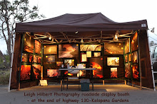
 Sunset from behind my lava photo display booth last week. (I have been dealing with a throat-chest & head cold for five days… 1st cold in four or five years, but it has kept me home and off of the lava fields… I'm getting better now so maybe this week I will have some more 1st-hand reports to share)
The rhythmic pulsing of the magma reservoir pressures I point out from time to time did not materialize beyond the first two ‘beats’ this week. Instead, the beats became quit erratic and on the low side as the D/I monitors currently show:
 Sometimes when we get sharp pressure swings upward for a day or two in these past few months, there have been corresponding molten lava breaks along the extensive lava tube system.
~~~~~~~~~~~~~~~~~~~~~~~~~~~~~~~~~~~~~~~~~~~~~~~~~~~~~~~~~~~~~~~~~~~~~~~~~~~~~~~~~
I will repeat most of my last update because it remains valid:
Kilauea eruption viewing update:
Both day and night views of our two drive-in volcanoes continue to put on a continuous display of eruptive activity that draws thousands of visitors from around the world every week.
The Halema’uma’u crater has been degassing sulfur dioxide fumes by day and glowing strongly at times after dark from lava deep within the craters pit vent.
 Great views of this impressive crater are from the Jaggar Museum balcony within the Hawaii Volcanoes National Park, depending on the weather; and the park is open to the public 24 hours a day with a nominal entrance fee by day.
 Meanwhile, down along the Big Island’s coastline, many people are still making the trek out to the end of highway 130 and on to the Kalapana access road and seeing sights like those in my photographs above. For update information on the viewing area, phone the county lava-hotline at 961-8093, or after 2:00 PM: 430-1966 or 217-2215. Changing wind directions can affect the costal viewing, phone before heading out there.
USGS images page has this nice aerial and caption below, which, even though it was taken 9-weeks ago, gives a good overview of mountain to sea eruption zone activity:
 USGS caption: “A wide shot of the coastal plain showing the Puhi-o-Kalaikini ocean entry in the foreground, producing a medium size steam plume. Fuming areas on the hillside mark the trace of the current lava tube, which confines the lava until it ultimately reaches the ocean. The road that abruptly ends is Highway 130, which currently hosts the County viewing area.”
Below, the view from the County viewing area this week:

 Click on the panoramic for a larger size image


Aloha Leigh! watching and monitoring your site for the lava flows...hope to meet you 1 day @ end of Hwy 130...here's a health tip from a friend of mines...I am dealing with a swollen ankle as a result of a fractured heel bone from an auto accident...the magic word is papain..in papaya..google it and try it out! fyi..Foodland Stores have a sale on it ends tomorrow.
ReplyDeleteHi Leigh! Amazing photos, and sounds like the view from your house is pretty nice, too! :)
ReplyDeleteBe on the island next week, have heard a lot of conflicting stories about lava viewing. Are there viewing opportunities beyond the county viewing area?
Keep the blogs comin!
Erin
@ Chauncey
ReplyDeleteNo conflicts: The official lava viewing area has often had visible molten lava near and far from it over the past couple of months, including right now.
Also there are various walk-in guided tour options. When you get here, drive to the end of highway 130 and keep going onto the single lane road another mile or so and you will arrive at the parking lot for the Hawaii County viewing road-walk. You will then be able to find out what the current lava viewing is, as well as finding out about local tours from local Kalapana Gardens residents and from other local guided tours. Maybe we'll see you there ;)
~~~~~~~~~
And thanks for the health tip Wayne
Thanks, Leigh! We will stop by if we see your display up.
ReplyDelete:)