Saturday, October 30, 2010

~ A few distant surface lava flows and two-pronged ocean entry plumes ~

Click the image for a larger view but in a new window.

Above, I have added some notes to a recent USGS aerial photo, which covers the general update for the Pulama Pali and coastal flats eruptive zones, as well as the delta ocean entry.

Below is a photo kindly contributed by a Kalapana Gardens resident showing a close-up of the current surface lava breakout that is nearest to the lava viewing area, which is now less than a mile distant(undocumented)and progressing generally to the east towards Kalapana Gardens. There are other breakouts further away near the base of the pali and flats.

~~~~~~~~~~~~~~~~~~~~~~~~~~~~~~~~~~~~~~~~~~~~~~~~~~~~~~~~~~~~~
Kilauea eruption viewing update: (Little change this week)
Both day and night views of our two drive-in volcanoes continue to put on a continuous display of eruptive activity that draws thousands of visitors from around the world every week.

The Halema’uma’u crater has been degassing sulfur dioxide fumes by day and glowing strongly at times after dark from lava deep within the craters pit vent. Great views of this impressive crater are from the Jaggar Museum balcony within the Hawaii Volcanoes National Park, depending on the weather; and the park is open to the public 24 hours a day with a nominal entrance fee by day.

Meanwhile, down along the Big Island’s coastline, many people are still making the trek out to the end of highway 130 and on to the Kalapana access road and seeing distant red surface lava glows after dark and the continuing ocean entry lava plume. The viewing area is open from 2:00 PM to 9:30 PM daily. For update information on the viewing area, phone the county lava-hotline at 961-8093, or after 2:00 PM: 430-1966 or 217-2215. Changing wind directions can affect the costal viewing, phone before heading out there.

Thursday, October 28, 2010

~ A few lava breakouts on the pali and flats ~


Just a quick and late update:

From midnight of the 26th to midday of the 27th, as the inflation pressure of magma peaked out, the extra pressure produced was possibly the force that pushed more lava into the tube system than it could handle; causing molten lava breakouts to erupt in several locations in the past day.

At its peak pressure timeframe, lava broke out about one-mile due west of the county coastal lava viewing area and after dark a little bit of this could be seen from the access road. Very early this morning, Kalapana Gardens residents reported a sizable river of lava flowing on the surface down the Pulama Pali. These types of breakouts have not lasted more than a day or two before crusting over during the past few months. Perhaps tonight we will get some new reports.

The ocean entry lava continues to be active and appears as two entries, even though it is just lava entering the ocean at two separate parts of the lava bench on the western end.

A lingering chest cold is still holding me back a bit; hence the missing lava reports.
The time at home has not been all rest though; I have been chipping away on a large, and exciting, lava movie project …

Monday, October 25, 2010

~ No recent surface lava but ocean entry flows on ~

Sunset from behind my lava photo display booth last week. (I have been dealing with a throat-chest & head cold for five days… 1st cold in four or five years, but it has kept me home and off of the lava fields… I'm getting better now so maybe this week I will have some more 1st-hand reports to share)

The rhythmic pulsing of the magma reservoir pressures I point out from time to time did not materialize beyond the first two ‘beats’ this week. Instead, the beats became quit erratic and on the low side as the D/I monitors currently show: Sometimes when we get sharp pressure swings upward for a day or two in these past few months, there have been corresponding molten lava breaks along the extensive lava tube system.

~~~~~~~~~~~~~~~~~~~~~~~~~~~~~~~~~~~~~~~~~~~~~~~~~~~~~~~~~~~~~~~~~~~~~~~~~~~~~~~~~

I will repeat most of my last update because it remains valid:
Kilauea eruption viewing update:
Both day and night views of our two drive-in volcanoes continue to put on a continuous display of eruptive activity that draws thousands of visitors from around the world every week.

The Halema’uma’u crater has been degassing sulfur dioxide fumes by day and glowing strongly at times after dark from lava deep within the craters pit vent. Great views of this impressive crater are from the Jaggar Museum balcony within the Hawaii Volcanoes National Park, depending on the weather; and the park is open to the public 24 hours a day with a nominal entrance fee by day.

Meanwhile, down along the Big Island’s coastline, many people are still making the trek out to the end of highway 130 and on to the Kalapana access road and seeing sights like those in my photographs above. For update information on the viewing area, phone the county lava-hotline at 961-8093, or after 2:00 PM: 430-1966 or 217-2215. Changing wind directions can affect the costal viewing, phone before heading out there.

USGS images page has this nice aerial and caption below, which, even though it was taken 9-weeks ago, gives a good overview of mountain to sea eruption zone activity: USGS caption: “A wide shot of the coastal plain showing the Puhi-o-Kalaikini ocean entry in the foreground, producing a medium size steam plume. Fuming areas on the hillside mark the trace of the current lava tube, which confines the lava until it ultimately reaches the ocean. The road that abruptly ends is Highway 130, which currently hosts the County viewing area.”

Below, the view from the County viewing area this week:
Click on the panoramic for a larger size image

Friday, October 22, 2010

~ The show goes on ~

CURRENT MOON
Tonight: Hunters Full Moon in the northern hemisphere, and Spring Full Moon in the southern hemisphere.

Ocean entry just south of some Kalapana Gardens homes by only a quarter mile. Photos above and below taken two nights ago from the Hawaii County lava viewing access road. Below is a photo I snapped looking out west across the fuming coastal flats towards the active lava tube system that has been busting out with molten lava breaks for a couple months now; off & on; the red glows are more of those breakouts.

Pele’s pulse rhythm is appearing again on the USGS deformation monitors. I find this regular pulsing of a massive magma reservoir quite interesting; like we are at times getting to hear, or watch, our earth’s heartbeat.

Kilauea eruption viewing update:
Both day and night views of our two drive-in volcanoes continue to put on a continuous display of eruptive activity that draws thousands of visitors from around the world every week.

The Halema’uma’u crater has been degassing sulfur dioxide fumes by day and glowing strongly at times after dark from lava deep within the craters pit vent. Great views of this impressive crater are from the Jaggar Museum balcony within the Hawaii Volcanoes National Park, depending on the weather; and the park is open to the public 24 hours a day with a nominal entrance fee by day.

Meanwhile, down along the Big Island’s coastline, many people are still making the trek out to the end of highway 130 and on to the Kalapana access road and seeing sights like those in my photographs above. For update information on the viewing area, phone the county lava-hotline at 961-8093, or after 2:00 PM: 430-1966 or 217-2215. Changing wind directions can affect the costal viewing, phone before heading out there.

USGS images page has this nice aerial and caption below, which, even though it was taken 9-weeks ago, gives a good overview of mountain to sea eruption zone activity: USGS caption: “A wide shot of the coastal plain showing the Puhi-o-Kalaikini ocean entry in the foreground, producing a medium size steam plume. Fuming areas on the hillside mark the trace of the current lava tube, which confines the lava until it ultimately reaches the ocean. The road that abruptly ends is Highway 130, which currently hosts the County viewing area.” Click the images for larger view size.

Below, the view from the County viewing area this week:

Wednesday, October 20, 2010

~ Heavy rains pound Puna - Lava fields stream up ~

Photo above is Hawaii County Civil Defense lava viewing area yesterday afternoon, courtesy of local resident. Click on it to view a larger size)

Heavy rains hovered over much of the entire coast from South Point to Kumukahi, the most easterly point of the Big Island, as well as from Kumukahi north up past Hilo into the Hamakua coastline. Thunder-lightning cells blasted Hilo to Pahoa as the evening progressed, ending by 11:00 PM in the Pahoa area, Hilo maybe longer.

Kahului and the Hana areas of Maui also had some serious rains and flooding last night. We need rain. The islands have been suffering from abnormal draught conditions this year. The National Oceanic and Atmospheric Administration (NOAA) issued a summery of this:
Summary of dry season:

• Statewide: Drought worsened
o “Exceptional drought” (D4 category in U.S. Drought Monitor) spread to Kau
o “Moderate drought” (D1 category) went from 50% in May to 74% September
• Leeward Big Island “severe” (D2 category) to “exceptional” drought
o Worst conditions in South Kohala and south Kau
o Some improvement in Kona coffee belt from summer rainfall
• Drought broadly affecting agriculture
o Livestock, orchards, crops, ornamentals affected
• Windward rainfall frequency near normal but daily totals below normal
• Hilo and Kapapala Ranch remain on pace for driest year on record.
o Hilo: 37.05 inches through September, normal is over 90 inches.
§ Record driest year: 1983, 68.09 inches
o Kapapala Ranch: 5.41 inches through September, normal is 42 inches.
§ Record driest year: 1998, 13.42 inches


Viewing area update
Regardless of the rains, many people still made the trek out to the end of highway 130 and on to the Kalapana access road, though the viewing area closed a bit early due to the rains.
For update information on the viewing area, phone the county lava-hotline at 961-8093, or after 2:00 PM: 430-1966 or 217-2215. Changing wind directions can affect the costal viewing. Onshore winds may close the viewing down. Right at the moment winds have switched and coming in from the southeast - as opposed to our usual northeast Trades, but this will likely swing around later today.

Visitors did see some red lava in cracks near the road and a steaming & fuming coastal flats yesterday, as well as a strong ocean entry plume beyond, as shown in the panoramic photo.

This morning mostly clear skies have returned, though the local forecast calls for possible heavy showers later today or this evening.

But so far we have a nice Hawaiian start to the day ;)
Sunrise through the ocean entry steam plume.

Monday, October 18, 2010

~ Creating volcanoes out of volcanoes ~


Master glass-blowing artist Kimball Trump creates mini molten volcanoes using raw 2000-degree lava and his glass-blowing pipes. Here is one next to his still-hot glassblowing pipe:

Movie footage and stills shot last night out on the coastal plans surface flow breakouts.After making four volcanoes Kimball created a foot and a fish then returned them back into the molten lava.


Watch the four-minute movie of this by clicking on the YouTube window below -- Click on this link to open it fully in YouTube (Note if you double click on the movie here you may end up loading both movie clips at the same time):


Coastal viewing update
Last report I received was last night; that the surface flow had made some more small gains by was nearly stalled. I will update this later today if something more exciting is happening there.

Saturday, October 16, 2010

~ Lava viewing area has lava to be viewed ~

Above: Under moonlit clouds, we see molten lava approaching the Hawaii County lava viewing area just after 10:00 PM closing time last night (ocean entry lava plume is the yellow glow furthest left).

Visitors who stayed at the viewing site until after dark were treated to a rapidly advancing surface flow of lava. Originating from the main lava tube west of this area, lava broke out from it early Friday afternoon and by early evening had progressed about 1600 feet east.

The access road and county viewing site are on the upper left, which places this lava very close to it at 11:00 PM last night.
Here we see local residents viewing the new roadside show last night. The flow traveled from the tube system right in overtop the same land covered just two weeks ago, as reported here.


By early this morning, when these photos below were taken, the breakout was slowing way down and had not progressed too much more than the night before, and may stall altogether later today. The ocean entry plume can be seen in this image.
The nearest homes to this molten lava were around 1100-feet away, but the stalling of this lava should provide some ease to the threat.

A Kalapana Gardens resident sent me the photo below taken a few hours after I left the area early this morning. We can see that lava moved out onto the road in that short time period ... maybe it is not done advancing afterall....

There are other sprawling fingers of this flow that moved southeast from the lava tube, and they too appeared to be stalling by 6:30 this morning.

Not any particular D/I events except for the missing monitor graph line for Kilauea this morning:

Thursday, October 14, 2010

~ What is an ocean entry delta or lava bench? ~

Above: the east end of the active lava delta just south of Kalapana Gardens, Island of Hawaii. Taken last week, this is the least active end of the bench; at least on this day. Notice the older sea walls running down the coast; everything below that is new land and still hot. To our right in this photo lava is pouring into the sea. Below shows the formation of that same section on August 7th, 2010August 7th, 2010 -- Bench progress after two weeks.

Around 2:00 PM on July 25th of this year a strong surface flow of lava breached the Hakuma horst and reached the sea. Molten lava pushed over the older sea wall cliffs and into the ocean; instantly beginning to form new land and black sand. Below: The Hakuma horst two days before lava breached it and found the ocean. (The images below are from the USGS Images page)

The new land being created is called a lava delta or lava bench and within two weeks there were nearly 20 acres of delta formed that jutted out into the ocean nearly 500-feet at its furthest point but also extended east and west producing 3000-feet of new coastline and a few continuously changing black sand beaches. Below: progress of delta formation on day nine to ten:

Eleven weeks later and lava continues adding more land along this new delta. But at the same time, due to the inherent instability of this kind of rapid lava-land creation, these deltas are highly prone to collapse. I have never seen one that did not collapse either partially or completely during the thirteen years I have been studying them along the south shores of the Big Island. (Continued below images...)

Below: Delta formation on August 6th:
Below: Delta formation on August 13th:

Below: Delta formation two weeks ago, September 30th:

When a lava delta breaks apart it can be piecemeal or in massive chunks. This can take place in minutes or slowly over many weeks or months. A break up of an active lava bench, one with lava moving through it, can be from mild local explosions as a smaller chunk of say 15 feet square falls into the sea, or incredibly violent with scalding tidal waves and massive littoral explosions of raw lava, ash, steam and propelled rock fragments {tephra}. Again, as posted before, check out this classic example of an entire lava delta collapsing. Notice the similarity to our current active delta.

Sometimes the delta sections do not simply break off but will fracture, allowing sea water to enter the cracks and contact the raw conduits supplying the raw and nearly 2000-degree lava within them. This can result in extremely explosive events; sending sheets of red-hot lava into the air. This can take place anywhere across an active delta that contains moving or stored molten lava. You can watch a USGS movie clip of that HERE

Sometimes there are warning signs ahead of either type of lava delta breakdowns: large or small cracks will form along the bench; these can be signs that the bench is fatiguing and about to break. These cracks can also form all the way inland within the old sea walls. On large bench collapses even the adjacent older cliffs can be fractured and fall into the sea. Ever-widening rock fractures there are often a forewarning. Also pre-collapses may begin with the delta shaking or making rumbling sounds.

…. And for an in-depth description about how lava deltas are formed and their inherent dangers, the USGS has an extensive page on that HERE

Meanwhile… coastal lava flow update:

From the Hawaii County viewing area road we can still see a robust ocean entry plume, which glows red-orange at night, as well as a few sporadic surface breakouts that are sometimes too far away to see well, but do occasionally break closer to the viewing area.
During the day the Pulama pali can be seen hosting long lines of degassing lava tube fumes.

Phone the Civil Defense lava hotline for current updates of openings or closures: 961-8093 (new updates sometimes are not announced until after 2:30 PM. After 2:00 PM you can phone the security staff at the viewing area at these two numbers: 430-1966 or 217-2215

Wednesday, October 13, 2010

~ Kilauea Volcano eruption – historical perspective ~

Steaming rocks on newly formed black sand beach being created by molten lava entering the ocean at this time.

This simplified illustration above offers a rough idea of previous lava flows on the Big Island in the last seventy years or so. The other one below is a general cutaway side view cross-section looking easterly of the eruptive circuitry of our more recent activity.Below: Lava tube today that carries a river of molten ava to the sea, and a fuming/degassing Pulama Pali in the distance.

Time capsule: 1960 Kapoho lava flow (My property boarders this flow.)
From the site: The 1960 Kapoho eruption and its predecessor, the 1959 summit eruption in Kilauea Iki Crater, together formed a summit-flank sequence that has been considered a model for how Kilauea "should" behave. The Kapoho eruption caused havoc in lower Puna, an idyllic rural paradise until the lava fountains and flows covered farm land and villages.

Or for some classic entertainment check out some of these informative USGS movies (Actually one movie in four parts. Pretty amazing footage for the day):
1959-1960 Kilauea Iki and Kapoho lava flow overview - 5-minutes long

Kilauea eruption 1959-1960 Chap 2 -10-minutes

Eruption of Kilauea 1959-1960 Chap 3 10 minutes

Eruption of Kilauea 1959-1960 Chap 4 - 2/1/2 minutes Kapoho eruptive fissures

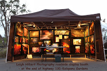
For those wishing to meet me or get signed copies of my lava movie or canvas prints, I will have my display booth set up in the vender parking area for Hawaii County’s lava viewing between 4PM and 9PM today and possibly tomorrow too. To get there you drive beyond the very end of highway 130, where it becomes single lane, about a mile to where the road is posted closed and you see the parking security staff. My booth is the large brown one:

To make sure the viewing area is open on any given day, Phone 961-8093 for Civil Defense lava hotline updates (after 2:30 PM to be really sure; they check conditions around 2PM each day). For on site information (best direct info) during the 2PM to 10PM viewing hours you can phone either: 430-1966 or try 217-2215

Monday, October 11, 2010

~ Pu`u O`o bubbling lava lake and other goings on ~


Activity all through the eruption zones from Halema’uma’u lava-filled vent to Pu`u O`o crater encrusted lava lake, as well as the lava tube surface breakouts and the ocean entry have all been going through swings of all sorts this past week: meaning basically that all these zones exhibited strong lava shows the past week then abruptly diminished.

These swings were also reflected on the electronic tilt monitors stationed at Kilauea Caldera and the Pu`u O`o crater as show in the graph here:

During the height of activity October 6th, USGS took some good aerial clips of the new molten lava activity within the Pu`u O`o crater floor and have them posted on their Imagespage. Here is the link to that clip

I have not been able to get out to the coastal lava flow areas for a few days but from what reports I have obtained there seems to be little change from my last posting except for a decrease in surface flows along the lava tubes and a slight decrease in the ocean entry lava. ( My Internet service provider was down yesterday so I was unable to post my blog).

Kilauea Volcano Facts: Extrapolated
from USGS volcanic gases page.

Laze plumes are very acidic
Extreme heat from lava entering the sea rapidly boils and vaporizes seawater, leading to a series of chemical reactions. The boiling and reactions produce a large white plume, locally known as lava haze or laze, which contains a mixture of hydrochloric acid (HCl) and concentrated seawater. This is a short-lived local phenomenon that only affects people or vegetation directly under the plume.

Avoid standing beneath a laze plume
Dense laze plumes, such as that shown here contain as much as 10-15 parts per million of hydrochloric acid. These values drop off sharply as the plume moves away from the lava entry areas. During along-shore or on-shore winds, this plume produces acid rain that may fall on people and land along the coast. This rain (pH 1.5 to 2), often more acidic that lime juice or stomach acid, is very corrosive to the skin and clothing. Visitors to the lava entry areas should avoid standing directly in, under, or downwind of the laze plume.