Sunday, August 15, 2010

~ Bench collapse movie clips for non-believers ~ No significant lava flow changes ~

Yesterday I re-posted a warning about the serious dangers with being close to new lava deltas, also termed lava benches. These benches are the rapidly formed lava zones that are solidifying and extending beyond land already in place: molten lava filling in along a coastline and building out into the ocean. The current Kalapana lava bench is nearly 20-acres in size. To make the dangers as clear as I can, I suggest watching this USGS time-lapse set of photos made into a QuickTime movie of a 32-acre lava bench actually collapsing… This will be a wake up call for those that ignore warnings about these events; and these events can happen over hours or seconds… (I find these QuickTime clips slow to load {very slow at the moment: one-four minutes some say} but this one is well worth the wait): East Lae`apuki Lava Delta Collapse (8.5 MB) The original clip and caption can be opened Here

Lava flow update:
No significant changes since yesterday anywhere within the eruptive zones that I am aware of. Magma pressures are bouncing up and down a bit but along normal parameters.

The small lava outbreaks near the base of the pali, in line with the lava tube system, are still active. The one remaining ocean entry south of Kalapana Gardens subdivision continues but is still much weaker than during the previous week. After dark the steam from the entry plume glows orange to red as seen from anywhere within a couple miles of that area. Daytime lava tube degassing fumes are visible from the Hawaii County lava viewing access road.

Nice day to head for the beach ;)

Saturday, August 14, 2010

~ New lava benches are very dangerous ~ Coastal flats a fuming lavascape now ~

I snapped this photo above out my window on the way down highway 130 yesterday. It shows a large portion of Kalapana Gardens subdivision with the steam ocean entry just beyond the Hakuma fault forest. Click on it for a larger size.

In the above photo, all the land just beyond the houses, and all the way to the right, (between the escarpment and houses) is where molten lava moved into from July 18th until August 2nd, at which time the lava ceased its forward expansion, stopping just short of several homes; though one home was destroyed on July 25th . The photos below were taken out on that hot & fuming lavascape.
The mango forests are mostly all lava covered now but as these two photos show there are a few trees still smoldering on the coastal flats; the steam from the ocean entry plumes in the background. It was on this lavascape, when the lava was first moving through there, where I found the mango tree for my ‘Lava heated mangos’ story.
(Click on the pictures for a larger image size)
-----------------------------------------------------------------
This morning I got a phone call reporting that rescue teams were summoned in to look for “some stranded visitors out on the lava flow”. This report prompts me to re-post a warning I placed on my blog last week:
STAY AWAY from new lava benches!!
These deltas, or benches of raw new land are being formed by the hour out into the ocean and along the shores; they are becoming rapidly unstable and prone to collapse without warning into the sea. A bench collapse can be very violent and create explosions of flying molten rock fragments and/or, send scalding mini tidal waves sweeping inland – even up onto older stable land adjacent to a collapse. A bench collapse can also pull older, previously stable, sea cliffs with it –! (Click on the photo for a large image size)(original photo without my notes is posted on the USGS/HVO>images website page. They also have a lot of other images and information on there worth checking out)
Also: a sudden onshore wind shift inland near the new ocean entries will bring with it a thick super-toxic mix of super-hot steam, rock-glass fragments, hydrochloric acid and other noxious gases…. A proper respirator is absolutely essential anywhere near the ocean entry zones! The other day I saw a random ‘tour’ group walking all along the billowing lava delta zones where they are essentially trapped between thick forest and the unstable, fuming, active lava benches. When the wind shifted on them they disappeared in a fog of toxins—that is bad and can kill you or destroy lung tissue, and burn eyes, among many other detrimental things… That area is NOT a place to be hiking close to or taking random tourists into period!
-----------------------------------------------------------------

Visitors to the county lava viewing access road during the day were able to see a line of degassing lava tube fumes trailing down the Pulama pali and out across the coastal flats, as well as the large stream plumes generated where molten lava continues pouring into the ocean a mile south of the road. By night a few small distant red-orange lava breakouts have been seen and the ocean entry steam alights with nice lava colors.

For more information about the Hawaii County Civil Defense lava viewing, phone 961-8093. If you listen to the recording you will be offered another phone number to call that will often be answered by security staff that are on location at the viewing site. The viewing area is open between 2:00 PM and 10:00 PM daily; last car allowed in to park is 8:00 PM.

Friday, August 13, 2010

~ Subdued lava action on the coast yesterday - inflation may ramp it back up ~

Click on the images for a larger view size.
As shown in my photo above taken at 10:00 PM last night from the Kalapana Gardens access road (County lava viewing area), a few surface breakouts of lava were visible in the distance (the small glow on the lower right is one of these). This photo was shot at 16mm, so even a small glow is fairly large on the ground.

Judging by the smaller ocean entry plume glow after dark last night the amount of lava pouring into the sea is still strong but reduced yet again from its previous volume. This may change. As recorded on these tilt monitor graphs, inflation is coming back into the picture. It will be interesting to see how this affects the coastal lava should the pressures continue an upward trend.

I am a sucker for crescent moons and even more so when Venus joins in ;) Venus is not in this shot above but the photos below have both in them. I shot these images from right behind my display booth last night; I really like these big ohia lehua trees for framing a photo with ;)


I will be setting up my roadside photo gallery display one more night there at the county viewing area if you want to drop by and say hi, then I’ll be working on photo projects until next week.

Thursday, August 12, 2010

~ Deflation slows things down ~ Cruise ship tours ocean entry ~

Last night’s crescent moon setting, as viewed from my lanai.

D/I (Deflation/Inflation)– tilt meter graphs are reflecting the first solid deflation of the magma pressures in four days, and have done so for more than 24-hours now, which is likely why I witnessed a reduction of action on the coastal flats and ocean entries yesterday; a pressure drop translates into less lava being pushed through the eruptive labyrinth all the way to the sea. It often takes many hours for a sudden D/I event to slow or heighten lava movement on the coastal flats or ocean entries due to the many miles the lava travels from the magma reservoirs.

Even those huge cruise ships slow down and take a look at the lava as they head from Hilo to Kona off the south side of the Big Island. I took this photo from the county lava viewing area; this is the glow from the one remaining ocean entry.

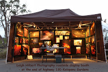
I occasionally set up a photo display booth next to the parking stalls at the Hawaii County lava viewing access road off the end of highway 130 in Kalapana Gardens area. I took this shot from inside my booth a couple of days ago:

I will be set up there from 2:00 PM until about 9:00 PM today if any of you would like to meet me or take a look at my large canvas photographs of lava or purchase a copy of my 84-minute movie of this lava flow ;) You can also enjoy seeing my friend Bruce’s beautiful lava images there as well on most nights.

Wednesday, August 11, 2010

~ Ocean entry diminished ~ Small lava outbreaks base of pali ~

(Above & below) A cloudy morning with light showers across the widest section of our new ocean entry delta revealed a much weaker flow of lava along the coastline than in previous days. Also the westerly progress extension has nearly stalled as of 6:00 Am. There were some occasional surges of lava, small explosions and minor shelf collapses during the two hours I was in that area.


Rays above the lava delta
Small lava breakouts into the sea

All along the shoreline steam swirls out of the fissures

Before daylight I also explored inland a bit to see if I could identify where these nighttime lava breakouts we have been seeing were actually located, or even still there. The only pronounced breakouts were a series of small ones running down the fuming lava tube line in the last 200 feet of elevation to the coastal flats. There was some spreading of lava directly off the south end of the tube system and onto the coastal flats. I took no photos.

Due west-southwest of Kalapana Gardens there continues to be heavy degassing of a broad area out in the middle of the inflated flats. Around 5:00 AM occasional brush fires and tree flare ups were taking place in the forest where the fox’s Landing lava had poured through twelve days ago.

Tuesday, August 10, 2010

~ Large surface flow breakout on pali – scattered breakouts across coastal flats ~

In yesterday’s blog post I voiced concern about where inflated lava may be flowing after a decrease in volume at the ocean entries. Some of the answer to that may be in what appeared last evening: By 9:30 PM last night a bright and growing breakout of surface lava became easily visible from the county lava viewing area located at the current end of the access road beyond highway 130. I guesstimated this lava was around the 800 to 1000-foot elevation, and others further up the pali but seen only as reflective glow. I snapped these pictures from there with a 300mm lens at 10:00 PM.

Less bright, but also easily spotted in the darkness, were a series of smaller lava breakouts scattered across the coastal flats from the base of the pali. One of these is pictured below and in it we can see forest fires (that look like large trees in the image)and/or asphalt smoke from that small remnant of pavement left near the old intersection of highways' 130 & 137, judging by how dense the smoke appears to be (click on the image for a large size): Due to darkness it was difficult to pinpoint exactly where these lower breakouts were, but they appeared to be located along the western edges of the tubing system between the pali base and old quarry area; a few others looked to be southeast of there, but all of these were well away from the access road and homes.

All these new breakouts, especially the upper Pulama pali one, may be helping to ease the inflation of the large hot mass of crusted lava adjacent to Kalapana Gardens; further reprieve for nervous homeowners there.

The breakouts may possibly also be lessoning the amount of lava entering the sea; the eastern ocean entry, which had recently been advancing quite strongly, remains stagnated, though the main ocean entry remains fairly strong. I took this photo below of it from the same location on the access road in Kalapana Gardens as the above images, also at 10:00 PM last night:

The USGS/HVO electronic tilt monitors are continuing to register steady inflation in a sort of holding pattern right now:

The Hawaii County lava viewing area is open between 2:00 PM and 10:00 PM daily; last car allowed in to park is 8:00 PM. Viewing area information can be found at 961-8093.

Monday, August 9, 2010

~ July – August eruption lava flow remains charged ~ Lava-heated mangos ~

Lava report:
Ocean entry lava flows have slowed down a little in the past 24-hours. The easterly expansion of shoreline lava near Fox’s Landing has nearly ceased advancing and the westerly most ocean entries have appeared to have also backed off production. This worries me. Inflation pressures beneath Kilauea have not subsided, which usually would indicate a continuation of lava pressures throughout the entire eruptive zones… So if the ocean entries are slowing down then where is that pressurized lava going ??

Possibly the lava is breaking out above the pali or somewhere along the tube system but I have heard no reports of that today - at least anything substantial … The next likely place would be within the coastal flats itself; a swelling, or inflation, of lava beneath the massive area of crusted lava that has been insulating this flow for weeks now. Such an inflation of the coastal plain lava would eventually bust out somewhere, and being that a large section of the flats are adjacent to Kalapana Gardens homes, that is where my concern lies.
~~~~~~~~~~~~~~~~~~~~~~~~~~~~~~~~~~~~~~~~~~~~~~~~~~~~~
The story of eating lava-heated mangos:Three weeks ago, July 19th, I had walked the advancing lava flow front just southwest of Kalapana Gardens. Molten lava was covering a large flat plateau of terrain covered in thick brush and long-abandoned mango forests; an area rich with a past history of human settlement.
As lava advanced across this old plantation area, lava-ignited brush fires raced ahead, scorching the landscape to black soot but often sparing the trees.

Lava followed the path of the scorched earth and slowly charred the trees bases - decimating those remaining, many of which were large old mangos that were dropping their last fruit for the season the day I hiked the area.

I came upon one grandmother mango whose base was still being slowly burned into by lava wrapped part way around and whose large overhanging limbs held ripe mangos right above hot cooling lava.


Some ripe mangos had recently dropped onto the hot-crusted lava and looked good enough to eat…It was a very hot day and degassing lava and smoked filled the air so I was wearing my respirator much of the time - and I had neglected to carry enough water; not a good combination. So when I spotted these little gems of fruit here and there on the lava I just had to try eating one. I picked one up and it was quite warm. I inspected it for fruit flies, but there were zero flies in this fuming lava zone anyway – I peeled back the reddish-yellow skin of this mango and steam wafted out and I took a bite--- Unbelievably delicious !!!

I ate that mango quickly and picked up another, consuming it as fast as I could – then another and another… I gathered a handful more and sat beneath the grandmother tree that had given me her last fruit of her long life, and while thanking her I must have eaten eight mangos — all lava heated. My face and hands were dripping with mango juice and I felt like a kid who got to eat all the sweets he wanted at the country fair…

Many local people knew of these hidden mangos there on the old homestead flat lands, some sharing with me their sadness at losing these great fruit producing trees.

But I shall forever cherish my sweet time beneath Grandmother Mango ~~

~~ New photos:
Click on the highlighted text to open my new online photography gallery of July through August lava flow images. (No mango tree pictures though ;)