Wednesday, April 13, 2011

~ Kilauea eruption confined within craters ~

Above, the rise and fall of magma pressure as recorded by USGS radical tilt monitors the past seven days: Halema’uma’u is the green line and blue for Pu`u O`o.

Little has changed in the past week within the Kilauea Volcano eruptive zones, though there certainly is magma movement and lava flowing. This activity is confined to lava upwelling inside both the Halema’uma’u and Pu`u O`o craters.

Halema’uma’u pit crater vent continues showing lava deep inside, visibly rising and falling from magma changes far below. Here is a cam capture from this morning:

The crater floor of Pu`u O`o, which had collapsed violently on March 5th when the new fissures erupted, has been filling with new layers of lava fairly steadily; below is a cam-capture of this from this morning.

Seismic activity also remains pretty subdued when compared with the past few years of active surface flows. Here is today’s map showing the past two weeks of quakes (all very tiny temblors):

One good thing for us folks living near these active volcanoes is the levels of sulfur dioxide being emitted from the two craters is holding well below the volumes we had for most of the past three years, which was then about 700 to 1200 metric tonnes or more and is now only 300 to 500 tonnes from both craters combined .

All this information I write about above comes directly from the USGS/HVO volcano update pages and can be found by clicking on the links they provide HERE

Further updates:
I will only post further lava activity updates as significant changes occur. If you need a lava-rush -(don’t we all ;) - I would suggest taking some time to wander through past posts on my site. We have had some amazing lava action in the recent past and you can relive it or find posts and photos you may have not seen.

The archives are not as easy to navigate as I would like but here are the basics:
Scroll down the right side of this page and you will spot Blog Archive. Click on a year (2010 is pretty exciting :) and it will automatically display the first posts in that year, but to see the titles or to select individual months you will need scroll back down the right side where you will see the post titles and the other months of that years postings. By clicking on any month it will open the first seven posts of that month; one above the other for an easy look-through. And at the top of each month’s page you will be offered a link to see the rest of that months postings, looking like this:
Showing newest 10 of 16 posts from October 2010. Show older posts

Meanwhile I'll keep looking for lava to share with you-


~~~ Happy Trails,
Aloha,
Leigh

Saturday, April 2, 2011

~ Interesting deflation tilt blip and little quake today ~


Above, Halema’uma’u at 1:00 PM today.

As we all wait for more eruptive changes with Kilauea Volcano, we also pay closer attention to any changes taking place now.Not large at 3.5 magnitude, but seems significant, especially after this odd drop straight down on the Kilauea summit tilt graph, shown below and copied at 12:30 PM today.
It is also very significant that during this recent magma pressure inflation/deflation stage that Pu`u O`o did not waver and appeared unaffected by the huge pressure spike at the Kilauea summit region; this after having been mimicking the summit the week previously. The Hawaii Volcano Observatory guys are all on it and will likely give us their viewpoints on this.
Might be a sign of bigger changes… or not ;)

The quake was four miles south-southeast from the summit. Here is a list of recent Big Island earthquakes, and also this link to the Hawaii Island earthquake map

USGS/HVO images page showing the new lava lake inside the Pu`u O`o crater last week, March 28th.


USGS/HVO updates

Radical tilt graphs

All the volcano webcams here


USGS/HVO images page showing the new lava lake inside the Pu`u O`o crater last week, March 28th.

Monday, March 28, 2011

~ Lava reappearing inside Pu`u O`o ~

Soon after my post two days ago when visible lava was rising once again deep down inside the Halema’uma’u crater pit vent, the massive Pu`u O`o Crater began doing the same. Above are a couple frames of those cam images I had saved from two nights ago. You can see this new lava lake, day and night, here on the Pu`u O`o rater cam (scroll down the many cam frames to see the crater floor).


Deformation radial tilt graphs, as shown in this morning’s chart, reveal magma is once again pressurizing below both craters, indicating the return of magma through conduits feeding the east rift of Kilauea, though both craters are now in deflation.

I was anticipating we might have a heightened earthquake activity associated with any return of surface lava, but so far seismic tremor is fairly low according to today’s USGS/HVO update and a recent earthquake map:

I am very interested to see what comes next with this volcano!
… Maybe we will once again see lava pouring into the sea and making the Big Island bigger, like it has so many times before:

Saturday, March 26, 2011

Halema’uma’u vent signs of life – Volcano quiet otherwise

Kilauea Volcano continues being very devoid of eruptive activity. This is pronounced considering the level of action this volcano has displayed over the past twenty-eight years.

US Geological Survey’s Hawaii Volcano Observatory updates, monitors and webcams have been keeping a close watch for any and all shifts in magma pressures and the accompanying changes. The changes have been remarkably subdued:

1) Deformation tiltmeters over the past two weeks have twice recorded inflation of magma pressures beneath Kilauea’s crater pit vent.

2) With those increases in magma pressures there has been a corresponding return of lava deep down inside Halema’uma’u’s pit vent. The most resent of these two events being last night on the crater’s overlook webcam, as shown in the top image that I saved at 11:00 PM. On other days we have not been able to visibly see any molten lava in the vent, just the degassing sulfur dioxide fumes.

3) Hawaii Island normally has dozens of small earthquakes each week, many of those from the 1.5 to 2.5-magnitude range and a few in the 3.0 and up size. But since the massive draining of lava March 5th and the spectacular fissure eruptions that followed for a few days, the only significant temblors were those I reported at Kalapana on March 11th. The smattering of tiny quakes on the map from today, posted below, depicts an abnormally quiet volcano.

4) Based on USGS reports, sulfur dioxide emissions are currently around 400-metric tons per day – this is way down when compared with the 1000 to 1700 metric tons per day during the past three years (with a huge spike of up to 10,000 tons during the recent fissure eruption)

Meanwhile a persistent forest fire has been advancing up into Hawaii Volcanoes National Park for the past few weeks. The fire was originally sparked by the Kamoamoa fissure eruption in the week of March 5th. The fire has now burned over 2000 acres and threatening an ecological reserve of unique plant and bird species. National Parks Service has called in fire fighters from California and Washington State to help stop the fire, which after two weeks of intense and difficult fire management is only 25 percent contained. One of the latest updates on the wildfire can be found here

WATCH-N-WAIT
Everyone here on the Big Island is in a watch-and-wait mode with Kilauea. I believe the last time this volcano became quiet like this was in 2007 when eruptive activity ceased for 10 days and over twice that in a 1997 eruptive pause. This time around the activity has been quiet for about 18 days depending on when you start counting. The most likely thing we might see occur now is earthquake swarms within some portion of the Kilauea rift zone, which would likely indicate an imminent new eruption there.

I will only post updates when significant new changes occur to the volcano. Have some fun and cruise back through the blog posts for previous months and years… It is really amazing how much lava and action has taken place with Kilauea just in the past three years! …. And in the past few decades!

You can follow the Hawaii Volcano Observatory updates here.

Monday, March 14, 2011

~ Pele’s naptime? – Kilauea Volcano pauses ~


After such dynamic activity last week with the sudden collapse of magma pressure within the two active craters followed immediately by those spectacular Kamoamoa fissure eruptions, the Kilauea Volcano has gone into the most inactive period since 2007 and 1997 before that:
- Tiltmeters nearly flat lined
- An unnerving 32 rapid earthquakes in a tight area at Kalapana, many over 3.0 and the one I felt quit well a 4.6 in magnitude – followed by almost zero seismic tremor activity throughout the whole of Hawaii
- No surface lava within either Halema’uma’u or Pu`u O`o craters or the new Kamoamoa fissure zone – or anywhere else; only remnant glowing in the rubble at the bottom of both craters and remnant fuming from all recently active eruption sites.

Unnervingly quiet. … But signs of change may be starting.

Without launching into all the details and geology and links that discuss previous Kilauea eruption pauses, it is suffice to say that this volcano has erupted nearly steadily for 28 years, and any pauses in eruptive activity in that time have been followed shortly afterward, usually within days or weeks, by a dramatic magma shift and pressure rise into some portion of the volcanoes historically active rift zone, which covers many miles of the south side of the Island of Hawaii.

One such event was the 1960 Kapoho eruption. (My house sits literally along the edge of that 1960 flow; A`a lava rises 15 to 20-feet higher, and borders, 700-feet of my property line. – if it erupts here again I could get some great fissure eruption photos from my upper lanai and I’ll hook up a live webcam for you!! :)

That said, — in the last 24 hours the tiltmeters are showing some significant inflation, but interestingly only under Halema’uma’u, and, both of the active craters are showing a slight increase in lava glow at night. Earthquake activity continues to remain low, and a change in local earth tremor is what we are watching carefully for because any major new eruptive site is preceded by swarms of earthquakes that can rapidly escalate into the hundreds per day, as it did in the summer of 2007.(Above-June 2007 Episode 56)

~~~~~~~~~~~~~~~~~~~~~~~~~~~~~~~~~~~~~~~~~~
A short account of my experience March 11th, 2011 related to the surge waves that arrived here in Hawaii as a result of the Japan’s devastating earthquake and tsunami:

In the early evening of March 11th I was closely watching our local earthquake graphs as two small temblors appeared right on the Kalapana lava flow area. I phoned friends at Kalapana to ask if the felt them, some had, others didn’t. Soon after, more small tremors were being recorded one after the other in the same location (more on that below). I also checked the world earthquakes site and saw a 7.9 magnitude earthquake had just taken place off the north coast of Japan.

Then a neighbor phoned and said the Japan quake was upgraded to an 8.8 (later upgraded) – a very serious quake that could easily produce catastrophic tsunamis for Japan, and eventually Hawaii and elsewhere.

As so many did, I began watching the news from Japan on the internet and also getting many phone calls from my neighbors because we live within a tsunami evacuation zone. Hawaii County Civil Defense announced a tsunami watch followed by a tsunami warning; my entire community prepared to evacuate, but I did not. The majority of homes in my community are virtualy at sea level, but I have the highest property in the community at the 65-feet elevation and it lays nearly a mile inland from the open ocean. So, just before 11:00 PM, while I was watching the unbelievable destruction news footage from Japan, the evacuation sirens began blaring loudly from the tower just down the road from me, and at the exact same time, my rustic post & pier three-story home suddenly began shaking from an earthquake! – A surreal moment for me; disorienting!

The shuddering did not last long but in light of the unfolding Japan quake and local volcanic events, it did get my attention! I already had our local earthquake chart webpage open and spotted the 4.6 that I had just felt—Kalapana had come alive with dozens of more temblors in rapid succession and concentrated in a small area—I was concerned a sloughing of the larger delta shelf may be in progress, which could lead to a major local quake & tsunami as it had back in 1975 that claimed lives here. In 1975, Kilauea's south flank was the site of the magnitude 7.2 Kalapana earthquake, the highest magnitude event in this century. The Kalapana coast subsided as much as 11 feet, generating a huge tsunami that claimed two lives in Hawaii Volcanoes National Park, destroyed houses in Punaluu, sank fishing boats in Keauhou Bay, and damaged boats and piers in Hilo.

Anyway, no Japan generated tsunami reached my community but there was some damage to the Kona side, but not worth mentioning compared with what Japan continues facing. My heart goes out to all of those people there who have truly lost not only their local communities, but entire cities very tragically washed away, and their inhabitants; many families lost.

~~~~~~~~~~~~~~~~~~~~~~~~~~~~~~~~~~~

Kilauea Watch
Here on the Big Island, we are now watching for a return of magma pressures beneath the two big craters and surrounding rift zones, and particularly a large and localized increase in seismic activity within the same zones. Sites to follow for this:
-- Magma pressures as shown on the USGS/HVO deformation graphs So far, only the Halema’uma’u is showing inflation—there may be some new separation of magma delivery between the two craters; directly related to the recent fissure eruptions.
-- USGS/HVO daily updates
-- Hawaii Island earthquake charts and lists (scroll down the list to see the recent Kalapana swarm and magnitudes.
-- Kilauea Webcams, particularly the Halema’uma’u and Pu`u O`o after dark. (You will need to scroll around on that Pu`u O`o one to see the lava glow inside the crater)

Mahalo for all the kind and supportive comments and emails this past week,
Aloha,
Leigh

Thursday, March 10, 2011

~ Fissure eruption slowing down ~ My last Big Island Video News update for awhile ~

Above: Setting moon above and framed by an old ohia lehua tree, the eruptive fissure lava reflecting off low clouds could be seen quite well from the county viewing area two nights ago — that glow can no longer be seen due to a stoppage of fissure activity last night.

The molten lava we have been witnessing pouring down the Pulama Pali and onto the coastal plains adjacent to Kalapana Gardens subdivisions for many months has completely ceased.

Though walk-in tour operators are feeling the pinch, property owners along the coastal plains are greatly relieved at this. It appears that for now, no more lava will come down into this area until a new eruption begins closer to, and above, the Kalapana region.

Historically, similar eruptive events as are now taking place have occurred. The most recent being the 1997 event when the active floor of the Pu`u O`o crater collapsed and a new fissure ripped open about a mile and a half southwest of Pu`u O`o crater by Napau Crater; nearly exactly like the March 5th fissure eruption that the USGS/HVO has been reporting on. In the 1997 event the fissure only lasted a few days, shut down, and then lava resurged back up into the Pu`u O`o region, producing new lava flows further east. But any of the active East Rift Zone on this island could come alive in the weeks ahead as things change-up with the magma movements below ground. USGS/HVO is reporting that the new fissures began pausing last night-- so now we sit and anxiously await what may come next-- Earthquake swarms are what I will be watching for in the days ahead.

So these new events leave me in a quandary as to what to report to you here on my daily lava blog… I do not want to simply mirror USGS reports, nor do I want to continue redirecting their reports from my site here… That’s what they do and they do it very well! I will ponder my choices for awhile…

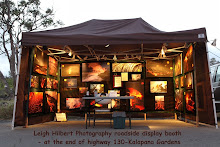
The coastal lava flow cessation will also rapidly affect me directly and a large part of my photography income: For the last two full years I have set up my humble little lava photo display booth at a vendors area in the parking lot of the Hawaii County public viewing area site off the nd of Highway 130 and peddled large canvas prints to those choosing to purchase them.

While at my display booth, it has also been a real pleasure to meet people who are there to witness our world wonder lava flows and talk story. Many of my Hawaiian Lava Daily fans from the Hawaiian Islands, and from the world over, have come by to say hi and meet me; and that has been a real joy!

Anyway, I will give some thought as to what report, and when to produce, further lava updates, and in the days ahead post something more about this while I seek other outlets to display my images and keep the bills paid. Anyone interested in viewing my ever-growing collection of lava photos, and have the opportunity to own one ;) then please visit my Professional Photography site here: Leigh-Hilbert-Photography lava galleries. Any support this way would be greatly appreciated! (Gee – did I just break my Ad-Free site code of ethics! ;)

Note: The Hawaii County Lava viewing area IS still open seven days per week and that will continue for an undetermined time whether flowing lava returns to that area or not. Visitors will still be treated to the awesome lava fields that extend for many miles right at the edge of Kalapana Gardens. I will continue to set up there for a little longer until the numbers of visitors dwindles too low to support my display business. And who knows, maybe lava will return faster than we think.

Okay—well I leave you with this: My latest (and last for awhile) Kalapana coastal lava flow update video and voice report that is now airing on Big Island Video News for today, March 10th, 2011. My two-minute lava update begins around the 3-minute 10-second mark within their full ten-minute report of Big Island events.

And if you are still desiring to see more recent lava in action you can always open my previous Kalapana lava field report from February 10, when we still had lava pouring into the ocean. This footage can be watched at the 1-minute 12-second mark of this three-minute February 10, 2011 Big Island Kilauea Volcano update newscast

As for the fissure eruption reports and crater changes just keep looking at all the inks at the top of this USGS/HVO site page.Location of the current eruption is in one of the more remote regions of Hawaii Volcanoes National Park, and about seven miles from Kalapana Gardens.

~~~ Aloha,
Leigh

Monday, March 7, 2011

~ New fissures continue to violently erupt – Coastal plains lava has all but ceased ~

Above is one of the many spectacular images that USGS/HVO crews have been documenting of the new eruptive fissures that are located between Pu`u O`o and Napau craters. I highly recommend checking out their new photos and videos and captions of this event on their IMAGES page. Their photo updates are images recorded yesterday. I believe the fissures are perhaps less explosive today, but I only base that on watching their new fissure cam, which may be very deceiving as to what is taking place on the ground along the fissures.

I have not been able to hike out to the coastal plains to see just how much lava may still be flowing; it has been raining very hard here. Reports I have received for the area say the lava has stopped flowing on the surface, but remains hot and steaming from the rains.

I will be compiling a set of video clips of the past month of coastal flats surface flow action for the local Big Island Video News and also post that raw video and the news version on here in the next few days.

No one knows what will happen next with the magma changes and lava eruption sites, but we are all excited to find out!

Until the surface flows are coming down the Pulama Pali or onto the coastal flats again I may not have as many updates, and will not have any new photos for you. I will not be hiking into the eruptive fissure zones that are currenty remote and inside National Park bouderies.

The lava Hawaii County Lava viewing site off the end of Highway 130 will remain open for visitors. There may be very little lava to been seen for a while but the area remains hot and fuming and steaming and is still a big attraction. For more information on this you can phone 808- 430-1966

To keep up with the activity within Hawaii Volcanoes National Park and the rift-zone eruptions you can follow the USGS/HVO daily reports.