(Click on the images for larger sizes)
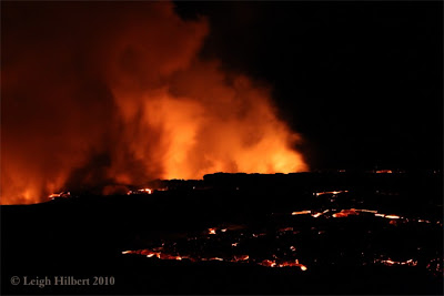
Shortly after noon yesterday, Pele’s latest surface flow of molten lava poured across the last stretch of land and into the open ocean with great fanfare. This is the first time lava has flowed into the sea here on the Big Island since the Waikupanaha ocean entry ceased on January 3rd this year.
Islander’s have been excitedly watching the progress of the surface flow make its way from the Pu`u O`o eruption site high atop the mountainside and down the Pulama pali, through the County viewing area kipuka (previous lava-spared forest remnants), sever the outer coastal flats viewing area, nearly overtaking the main trailhead viewing area, then down through more kipuka, and finally bursting dramatically out of the forest yesterday at 6:00 AM and reaching the ocean just after 12:00 noon, four hours later.
The public gathered on the trailhead viewing area in the afternoon and evening yesterday to gaze out onto the expansive acreage of still smoldering fields of pahoehoe. There continued to be some openly flowing breakouts of lava, which could be seen day or night. One of these breakouts has concerned County officials because it has moved down directly close and adjacent to the trailhead on the north side. This slow-moving, but still active finger of lava has the potential to spill down onto the terminus of State highway 130, which is presently the County parking location for visitors to the viewing area.
As of 10:00 PM last night there was no definitive word from State, County or Civil Defense personnel, nor the security company managing the area, regarding whether the original Waikupanaha public viewing area & trail will be opened again. There was some speculation that those in charge of these decisions might open it up today. I hope so, it is a spectacular scene to see – starting from the trailhead to the coastal viewing site: hot pahoehoe lava close by to the west of the trail, vegetation still burning here and there a safe distance away, and a wonderful view of still glowing lava entering the sea directly southwest and very close by to the old viewing site.
Lava Viewing Summary
1) The Hawaii County viewing area continues to be a good show and will be all the better if the outer coastal viewing site opens today. Phone Civil Defense at 961-8093 for their recorded update messages, which may not actually offer recent changes but will state whether the area is open or not, or 430-1966 for further information.
2) Halema’uma’u crater vent continues to spew a plume of sulfur dioxide by day and often exhibits a beautiful red glow by night. The Jaggar Museum’s overlook balcony within Hawaii Volcanoes National Park is the best viewing location of the Halema’uma’u crater.
Friday, April 30, 2010
Thursday, April 29, 2010
Lava breaks out of Kipuka 300 feet from the ocean
(Click on the images for a larger size)
The leading front of molten pahoehoe dramatically burned its way through the last piece of kipuka vegetation and poured spectacularly over a small pali at 6:20 AM this morning.
This lava flow will be touching the ocean water in one or two locations by early afternoon today. The location of the flow is amazingly convenient to public viewing should Civil Defense deem it safe enough in the days ahead. I say convenient because this flow has not severed any of the entire length of the old coastal viewing area trail or the gathering spot we had watched the Waikupanaha flow from for the past two years; until it ceased on January 3rd this year. Molten lava more or less parallels the original April 2008 to January 2010 trail all the way to the sea but does get as close as three hundred feet from the trail near the coastal end of it; where it is still active and spreading slowly. The land there tends to slope away from the trail so it might be spared, allowing for public access soon.
The lava flow front lies directly below the pali on the edge of old viewing site and will enter the ocean close by to the southwest today. It broke out of the forest this morning west of the old site about two hundred feet away. If the access trail survives, the original viewing site will be an ideal vantage point for the public to safely view the new ocean entries; at least as long as they last. This is a strong flow and may hang in there for some time.
Last night 13,012 people came down to the end of highway 130 and took the short walk out to the present designated viewing area and witnessed acres of mostly cooling pahoehoe. They gasped in excitement when the lava broke out yellow-orange and red; oozing into new formations. Hot lava was as close as fifty feet away and could be seen on three sides of that viewing area.
Lava Viewing Summary:
Depending on what changes Hawaii Civil Defense makes to the viewing access at the end of highway 130, I would think this would be the best show on the Big Island again… That said, I doubt they will open the old trail to the coast until the paralleling lava stops spreading nearby to the trail. But there continues to be good viewing of hot lava right from the currently chosen viewing spot; we should have a much better idea by tonight.
Wednesday, April 28, 2010
Goodbye to the viewing area? Maybe
(Click on the images for a larger size)
The Last Stand on a Moonlit lavascape:
After-hours. This is the only hut left standing on the edge of the official public viewing area (The third in four months) … I wonder if “Donations to keep the Kalapana lava site open” is going to have an affect here … Pele seems to be the big donator at this site now.
Below are viewers at dusk Tuesday:Looking southeast
looking west
Pahoehoe lava continued to fill the lower areas directly surrounding the public Hawaii County viewing area all day yesterday and into the night. By 10:00 PM the entire terrain on nearly three sides had risen and was within fifty feet of the last little County hut within the high point of the cordoned-off portions of the viewing area. If the rise has continued over night it looks quite possible that the advancing lava might (or already did) spill over the viewing area and flow back to the north east to begin covering yet another segment of highway 130 and kipuka forests, which is presently the parking area for visitors as well as headquarters for the security management overseeing the public lava viewing for the County. We shall find out later today…
The moonlit lavascape looking south from the viewing area at 10:00 PM last night. More forest burns in the distance.
The leading sea-bound edge of this lava flow is 600 feet south of the viewing area and maybe 3000-feet or so from the sea. The eastern edge of the flow was paralleling the old trail that led to the coastal viewing area. At its present rate of seaward thrust, this surface flow will be touch the ocean within two or three days I would expect…
On Tuesday, about one thousand visitors gathered in the afternoon and into the evening to witness Pele in action.
The only way to find out what the lava is doing there today is to drive to the end of highway 130 and find out. I will be out there in the afternoon. If I owned a cell phone and did the tweet thing I could give you an onsite report, but I don’t ;)
Up in the Hawaii Volcanoes National Park the Halema’uma’u crater pit vent has been glowing very bright red-orange on most nights this week.
Tuesday, April 27, 2010
Molten pahoehoe lava fills old quarry near County viewing, then crusts over
Monday night over a thousand people gathered on the newest County viewing area last night to gaze down onto a broad and hot acre of lava. The night before this area was twenty feet lower; an old rock quarry filled in with lava overnight, rising higher & wider prompting concerns of it overtaking the viewing area in the hours and days ahead.
But by 10:00 PM last night it appeared that the swelling expanse of lava would likely proceed south towards the sea as we witnessed fresh breakouts bursting from the southern edge of this leading surface flow, though it also showed a potential to continued swelling and possibly inundating the end of highway 130; again ;)
This new USGS lava overview flow map shows in red the location of the surface flow we are watching from the viewing area: (Click on the image for a larger size)
I did not have time to process my photos from last night of the people gathered and watching the lava.
Lava Viewing Summary:
1) At the County viewing area there should still be a large area of crusting over pahoehoe lava directly below and west of the latest designated viewing area, which is a short walk off the end of highway 130. There may also still be some hot breakouts of lava to be seen if it has not stagnated or moved beyond sight. Bring you tripods! The viewing area is open to the public between the hours of 2:00 PM and 10:00 PM; last car allowed in is 8:00 PM – seven days per week.
2) Strong crater pit vent glow is still being seen after dark from the balcony outside the Jaggar Museum during the day and after dark. The Jaggar is located a few miles past the entrance gates of Hawaii Volcanoes National Park and is open to the public 24 hour a day, seven days a week.
Video of the molten lava moving slowly through the kipuka forest three days before appearing in the open at the County viewing area:
Taken a few mornings ago, this is a seven-minute video of lava burning the forest in the kipuka. In this short movie, shot April 23rd at dawn, @ 1:40 you will see trees fall into the molten lava and burst into flames. The last few minutes shows a lava breakout pour down into ferns. Throughout the movie you will here the crackling of fires, thumps of small methane gas explosions, at least five varieties of birds chirping and one croaking buffo toad.
Monday, April 26, 2010
Molten pahoehoe reaches County viewing - spills spectacularly over pali
Click on any image to open a larger view window
Hawaii Civil Defense made a good call moving the County viewing area containers and huts further east on highway 130 the other day because on Sunday afternoon lava broke out of the adjacent kipuka forest with a mission and had reached the edge of viewing trail by late in the evening. I think Pele wants to touch the sea again. The photos below were taken there at dusk.
Lava Viewing Summary:
The place to be Monday afternoon and evening will be the County viewing area. There should be a large area of expanding pahoehoe lava directly below and west of the latest designated viewing area, which is a short walk off the end of highway 130. Bring you tripods! The viewing area is open to the public between the hours of 2:00 PM and 10:00 PM; last car allowed in is 8:00 PM – seven days per week.
(I am working on some new lava videos but meanwhile, if you haven't seen this one, check it out-- turn your volume on ;)
Video of the molten lava flowing down the Pulama Pali: (double click it to open in a new window)
Taken a few mornings ago, this is a seven-minute video of lava burning the forest in the kipuka. In this short movie, shot April 23rd at dawn, you will see trees fall into the molten lava and burst into flames. The last few minutes shows a lava breakout pour down into ferns. Throughout the movie you will here the crackling of fires, thumps of small methane gas explosions, at least five varieties of birds chirping and one croaking buffo toad.
Saturday, April 24, 2010
Molten lava slowly advances from the north and northwest of the County viewing area
Not much change from yesterday: Surface lava is flowing through the kipuka directly adjacent and to the north-northwest of the County viewing area. The closer surface flows of moving lava are just out of sight, obscured by the trees and vegetation, the same kipuka vegetations that are being inundated by lava from three sides. The more easterly kipuka flow is now barely advancing, while the west side is far more aggressive and may reach the, now closed, outer viewing area within a day or two if it continues strong and moving in the direction it is now. No lava has reached the ocean.
NOTE: watch it on this page or double click the video and watch it full size on YouTube or click HERE
This seven-minute video is of lava burning the forest in the kipuka. In this short movie, shot April 23rd at dawn, you will see trees fall into the molten lava and burst into flames (@1:40 and another @1:55). The last few minutes shows a lava breakout pour down into ferns (@3:30) and bursting larger (@4:40). Throughout the movie you will here the crackling of fires, thumps of small methane gas explosions, at least five varieties of birds chirping and one croaking buffo toad...
The above aerial was originally from a USGS images update on April 15th .(Click the image for larger size) I have added my own update notes to it. The red surface flow outline is a rough interpretation of where the hot zones are, but close enough to show how it is advancing into the kipuka newer the viewing area shown in my opening image.
Further up the coastal flats and Pulama Pali beyond we still see some serious swaths of lava that stand out red & orange after dark. Those more distant pali flows have dimmed a little the past 24 hours as they crust over and form tubes; or as they stagnate.
Lava Viewing Summary:
Weather permitting; the most visual displays of active lava continue to be safely witnessed from the two designated public viewing areas:
1) The balcony outside the Jaggar Museum during the day and after dark. The Jaggar is located a few miles past the entrance gates of Hawaii Volcanoes National Park and is open to the public 24 hour a day, seven days a week.
2) The newly advancing surface flow can be watched from the Hawaii County Civil Defense public viewing area parking, trailhead and the newly established gathering spot next to there. This area may become pretty exciting in the following days IF the lava close by continues its march through the kipuka forest and passes through, or nearby. The viewing area is open to the public between the hours of 2:00 PM and 10:00 PM; last car allowed in is 8:00 PM – seven days per week.
Friday, April 23, 2010
Molten lava continues a very slow march through the forest close to viewing area
(Click on the pictures for large sizes)
Surface lava is flowing through the kipuka directly adjacent and to the north-northwest of the County viewing area. The lava is mostly obscured by the trees and vegetation there, but further up the coastal flats and Pulama Pali beyond there remains some serious swaths of lava that stand out red & orange after dark.
Lava Viewing Summary:
Weather permitting; the most visual displays of active lava continue to be safely witnessed from the two designated public viewing areas:
1) The balcony outside the Jaggar Museum during the day and after dark. The Jaggar is located a few miles past the entrance gates of Hawaii Volcanoes National Park and is open to the public 24 hour a day, seven days a week.
2) The newly advancing surface flow can be watched from the Hawaii County Civil Defense public viewing area parking, trailhead and the newly established gathering spot next to there. This area may become pretty exciting in the following days IF the lava close by continues its march through the kipuka forest and passes through, or nearby. The viewing area is open to the public between the hours of 2:00 PM and 10:00 PM; last car allowed in is 8:00 PM – seven days per week.
Video of the molten lava flowing down the Pulama Pali:
Thursday, April 22, 2010
Pele on earth Day ~ Outer lava viewing area closed by advancing lava
Forest burns as molten surface lava moves through it. On the right is more advancing lava.(Click on the picture for a large size and to see the stars)
Yep, the security firm managing the area for Hawaii County, at about 5:00 PM yesterday, closed off the newly established lava viewing area. Visitors were allowed to gather on a rise of land close to the terminus of highway 130.
From that new vantage point spectators could still see the forest burning nearby as the molten lava beneath it moved through. And after dark a broad area of lava outbreaks could be seen far up on the mountain and down the Pulama Pali. Frequent rain squalls dampened the view but did not seem to dissuade the hundreds of people who attended.
Lava had not reached the viewing areas as of 10:00 PM last night.
(Click on it for a larger size) Above, the viewing area from the night before, April 20th, which may have been the last time this location will be accessible, lava may surround it in the next day or two.
Lava Viewing Summary:
Weather permitting; the most visual displays of active lava continue to be safely witnessed from the two designated public viewing areas:
1) The balcony outside the Jaggar Museum during the day and after dark. The Jaggar is located a few miles past the entrance gates inside of Hawaii Volcanoes National Park and is open to the public 24 hour a day, seven days a week.
2) The newly advancing surface flow can be watched from the Hawaii County Civil Defense public viewing area parking, trailhead and the newly established gathering spot next to there. This area may become pretty exciting in the following days IF the lava close by continues its march through the kipuka forest and comes closer. The viewing area is open to the public between the hours of 2:00 PM and 10:00 PM; last car allowed in is 8:00 PM – seven days per week.
Video of the molten lava flowing down the Pulama Pali:
Wednesday, April 21, 2010
Surface flow advances through forest near viewing area
Spectators gathered at the County viewing area last night to witness the advancing lava, which is still glowing strong high on the Pulama Pali as well as close by on the coastal flats and within the kipuka forest only a thousand feet away.
(Click on the images for a larger size)
Video of the molten lava flowing down the Pulama Pali:
Lava Viewing Summary:
The most visual displays of active lava continue to be safely witnessed from the two designated public viewing areas:
1) The balcony outside the Jaggar Museum during the day and after dark. The Jaggar is located a few miles past the entrance gates of Hawaii Volcanoes National Park and is open to the public 24 hour a day, seven days a week.
2) The newly advancing surface flow can be watched from the Hawaii County Civil Defense public viewing area parking & trailhead, and even better from the designated viewing area at the end of a 2200-foot walk across uneven pahoehoe lava. (The viewing area is still warm from the October 23-26th. 2009 surface flow!). This surface flow is best seen after dark. Bring good footwear, some water and a flashlight if you plan to take the trail hike out to the county viewing area and stay after sunset. If you have binoculars bring those along. The viewing area is open to the public between the hours of 2:00 PM and 10:00 PM; last car allowed in is 8:00 PM – seven days per week
Tuesday, April 20, 2010
Lava flowing down Pali onto coastal flats and fast approaching viewing area
New video of the molten lava flowing down the Pulama Pali:
Deflation came and went in the past 48 hours. This likely caused a temporary lessening of lava flowing down the slopes as best seen after nightfall a day ago, but visitors to the County Viewing Area are continuing to enjoy the distant lava glows. We are hoping it will pass close enough to the viewing area to allow for some good views of an active flow. In fact it appears this flow may overtake the viewing area and the management there have relocated their base further back up the road! Presently lava is now advancing into some vegetation near the viewing area. If you are on the mainland and want to possibly see molten lava close up, this week may be your opportunity. I will try to get an onsite look at this tonight.
USGS Hawaiian Volcanoes Observatory has posted some excellent overviews of the activity on their images webpage(Click on the image for a larger size)
Big Island Video News . com has posted a nice write up on the lava viewing, accompanied with some great video by David Corrigan, who I had the pleasure to meet out there a few nights ago after he shot his video for the linked piece above.
Lava Viewing Summary:
The most visual displays of active lava continue to be safely witnessed from the two designated public viewing areas:
1) The balcony outside the Jaggar Museum during the day and after dark. The Jaggar is located a few miles past the entrance gates of Hawaii Volcanoes National Park and is open to the public 24 hour a day, seven days a week.
2) The newly advancing surface flow can be watched from the Hawaii County Civil Defense public viewing area parking & trailhead, and also from the designated viewing area at the end of a 2200-foot walk across cooled pahoehoe lava. (Some sections of that lava walk are still warm from the October 23-26th. 2009 surface flow!). This surface flow is best seen after dark. Bring good footwear, some water and a flashlight if you plan to take the trail hike out to the county viewing area and stay after sunset. If you have binoculars bring those along. The viewing area is open to the public between the hours of 2:00 PM and 10:00 PM; last car allowed in is 8:00 PM – seven days per week.
A typical nighttime view will look like the picture I posted on my previous blog report here, or as seen in David’s video linked above.
Thursday, April 15, 2010
Strong magma pressures ~ Bright crater glow ~ Advancing surface flow
Click on the images for a larger size
The photo above is of the leading edge of the advancing surface flow of molten lava as seen looking south towards the coastal flats and the ocean beyond. The surface flow consists of a mix of more fluid-like pahoehoe and the jagged/chunky A`a type; both types, taken yesterday, are seen in the photo. The pahoehoe form of lava will likely dominate the flow as it reaches flatter ground further down. The public viewing area is located on the top upper left edge of the image where the remnant forest meets the open coastal plain; a distance of approximately 2 kilometers or about a mile and a half.
The advancing flow could be passing west of the viewing area in the days/weeks ahead. The lava is moving slowly at present, perhaps at a rate of 50-feet an hour, but that rate could change at any time.
After dark, reports from visitors to the Thomas Jaggar Museum within Hawaii Volcanoes National Park are of witnessing a very strong lava glow. A broiling lake of moving and molten lava with a base approximately 260 feet across and +/- 600 feet down inside a massive vent tube that reflects the lava colors up the vent and into the sulfur dioxide plume. The crater vents top opening is presently something like 460 feet in diameter and has been slowing growing in size since it first blew open in March 2007. Below is a saved image off the USGS Jaggar web cam last night and shows a very bright crater glow.
Lava pressures continue fairly steady and strong at both Halema’uma’u Crater, Pu`u O`o Crater and it’s adjacent eruption site. USGS HVO geologist say lava pressures beneath the Kilauea Volcano are often directly affected by changes in magma pressures within the large magma reservoirs below Kilauea. Sensitive tilt meter monitors placed strategically around the two craters record subtle bending/warping, or deformation of the crater’s rims. These changes are recorded constantly onto graphs, which the USGS kindly shares with the public on this page
Viewing Summary:
The most visual displays of active lava continue to be safely witnessed from the two designated public viewing areas:
1) The balcony outside the Jaggar Museum during the day and after dark. The Jaggar is located a few miles past the entrance gates of Hawaii Volcanoes National Park and is open to the public 24 hour a day, seven days a week.
2) The newly advancing surface flow can be watched from the Hawaii County Civil Defense public viewing area parking & trailhead, and also from the designated viewing area at the end of a 2200-foot walk across cooled pahoehoe lava. (Some sections of that lava walk are still warm from the October 23-26th. 2009 surface flow!). This surface flow is best seen after dark. Bring good footwear, some water and a flashlight if you plan to take the trail hike out to the county viewing area and stay after sunset. If you have binoculars bring those along. A typical nighttime view will look like the picture I posted on my previous blog report here
Monday, April 12, 2010
Surface flow advances further down the pali – dramatic after dark
Click on the image for a larger size.
Still about 1 ½ miles inland from the Hawaii County Viewing Area and a little over two miles from the ocean, the surface flow of lava is robust and quite easily seen from anywhere along the last mile of highway 130 and the viewing area beyond.
I took the photo above with a 300mm lens at around 8:00 PM last night from the visitor’s parking lot, which is the trailhead for the viewing area. In the photo you can see one very bright lava section, this is where a massive falls of lava broke over and down a steep pali (cliff).
This surface flow is crusting over itself as it moves down the mountain from the eruption zone, some four miles further up, forming lava tubes that insulate the hotter lava, keeping the length of the flow strong while delivering new lava to the leading edges. If this keeps up we should have a spectacular viewing of lava pouring across the coastal flats and perhaps reaching the ocean in the days, weeks ahead. The new County lava viewing area may be in a prime location for this.
At present, the flow is still over a mile and a half away from public access so binoculars are helpful to zoom in on it. And as usual, the lava is best seen after sunset. For new visitors to the area it is nice to be out there before dark to enjoy the raw lava landscape and then wait for nightfall, but you will need flashlights (oftentimes vendors there sell them). The County viewing area is open to the public from 2:00 PM to 10:00 PM, with last car allowed in at 8:00 PM; they are open seven days per week.
See my previous post for more information.
Sunday, April 11, 2010
Molten lava continues flowing down the pali towards the ocean and viewing area
The map above is a USGS update for April 8th. I have added a few notes showing where the new Hawaii County lava viewing trail and viewing location are. Click on the image for a larger size.
The USGS predicts this flow will continue down towards the new viewing area but go across the coastal flats just west of there. So that may become a fantastic chance to see it in the days and weeks ahead if it does keep advancing.
Below are two close up images of one of the two forms of lava comprising this new surface flow, A`a and pahoehoe. A`a is the more jagged of the two. These photos are of A`a and photographed by lava field researcher Ron Boyle yesterday afternoon:
In this image the molten A`a is flowing over older, fern strewn, pahoehoe.
And last night at around 7:30 PM I took this photo below from the lava viewing parking area parking lot showing a large portion of the surface flow, with the cloud edge backlit by the remnant sunset afterglow:
Friday, April 9, 2010
Lava activity continues at the crater and above the coast
I have not made it back out to either Halema’uma’u crater or the advancing lava above the coastal viewing area these past few days, but will do so tomorrow. The USGS Hawaiian Volcanoes Observatory site posted some excellent images yesterday: a QuickTime thermal movie showing the 260-foot wide broiling lake of molten lava inside the Halema’uma’u active crater vent, and ground & aerials showing the advancing surface flow.
Monday, April 5, 2010
Broad front of molten lava advances toward Kalapana coastline
Photo above taken with a 300mm lens from the parking area for the lava viewing trail at the terminus of highway 130 last night. Click on the images for a larger size.
An impressive line of glowing red-orange lava high up on the pali directly above, north, of the official public viewing area was noticeably advancing down the mountain after dark last night. About two hundred spectators showed up to watch this, sharing binoculars because the surface flow is still over three miles distant.
Many observers were speculating as to where this surface flow could arrive at when (& if) it completes the advance down the steep mountain face and onto the coastal lava flats and the ocean. Most guesses placed it at where we were standing – the end of highway 130: the trailhead for the public lava view area.
This is one of the most robust surface flows we have seen coming over the crest from the Thanksgiving Eve Breakout (TEB) since it first erupted in November 21st, 2007.
Inflation surged back into the magma chambers beneath Kilauea Volcano yesterday about an hour after I posted my blog reporting deflation, and has continued, as the USGS deformation graph below indicates.
The County of Hawaii lava viewing area is open from 2:00 PM until 10:00 PM daily. For more information phone the Civil Defense lava hotline at 961-6028. Parking for the viewing area is at the lava-covered terminus of highway 130 near Kalapana.
The Halema’uma’u crater has been glowing strongly at times after dark as viewed from the Jaggar Museum within the Hawaii Volcanoes National Park, and is open to the public 24 hours a day.
I will post an update on the advancing lava front in a few days, or sooner if it advances quickly.
Sunday, April 4, 2010
Lava activity returns within view of Kalapana coastline
A broad and thick line of advancing molten lava has finally come within sight of Kalapana and the official lava viewing area at the end of highway 130. This surface flow is above and to the north east of the now lava-destroyed Royal Gardens subdivision.
This appears to be an intense swath of A`a type of lava. It is hard to see in the daytime but after dark, if it is not raining, the scene is quite impressive. This lava has advanced substantially in the past few days but may now slow its progression due to a pronounced drop in magma pressures, deflation, under Kilauea Volcano. The lava is still about 3 ½ to 4 miles distant (bring binoculars) from the end of 130 but is heading down the cliffs toward the ocean and could possibly arrive somewhat close to the official viewing area; though it is much too early to tell what this new flow will do.
Beyond sight from public view is yet another surface breakout high above the pali, on the flatter ground. One field report claimed a large lake-like pool of lava there two days ago.
I was unable to photograph last nights A`a lava front because I misplaced a tripod mount, but I will try for a photo tonight and post it here tomorrow at this time.
The Halema’uma’u Crater has also been glowing very bright after dark as seen from the Jaggar Museum in Hawaii Volcanoes National Park. The crater’s glow intensity will likely diminish until inflation of magma pressures return in the days ahead.
Subscribe to:
Posts (Atom)