Saturday, August 7, 2010

~ From mountain to sea – Kilauea Volcano is pumping lava full-on! ~

Pu`u O`o crater and a little rainbow at 9:00 AM this morning
(Click on any image for a slightly larger view size)

From the D-vent eruption conduits near Pu`u O`o crater, down through a well established tubing system, across a sprawling & inflating coastal flats, along a subdivision, through forests and into the ocean – Kilauea is producing a large volume of molten lava right now. Above -Looking southeast from overtop the Pulama pali area

I was generously offered to hop aboard a charted Paradise Helicopter flight early this morning (Mahalo nui loa Greg!). The flight was piloted by the infamous Chief himself, Steve Kittrell; and he lived up to his reputaion today ~ Thanks Steve ;) I shot some movie clips but also a few stills, which I post above and below: Above is the widest section of the continually expanding lava bench of new and unstable land. In the background you can see the scorched jungle where the lava poured through two weeks ago.

Powerful ocean entry plumes

Below: One of many locations along the fuming coastline where rivers of lava are pouring into the ocean:

Above: A large skylight part way up the Pulama pali-- we could see the river of lava moving rapidly inside it.

Above: This is a fairly large break-out-of-the-tube river of lava coming down the Pulama pali; it broke out during my flight (about 8:30 AM)and was growing longer by the minute.

Below:USGS/HVO maps of hot lava zones as of August 5th, 2010 You can compare these with my aerial images for orientation on some of the photos. (Click on these for a nice large image size)


Above: Dated August 6th, USGS has provided another valued update of a thermal aerial view showing exactly where the heat is located within the coastal flats to the sea. This time the notes on the image were added by USGS/HVO personnel—Mahalo to them for posting these on their IMAGES webpage. Check out their other images on there too.

Inflation kicked back into to an already strong flow… we may be seeing some broader coastal flats inflation and breakouts because of that in the days ahead. Part way up the Pulama pali we witnessed a large river of lava that had just started at around 8:30 AM, which was likely a result if this new inflation period. (see photo with caption of that above on here)

Friday, August 6, 2010

~ Robust expansion of ocean entry lava benches ~ Coastal flat inflation continues ~

Two weeks straight of continual lava flows straight into the ocean area creating large lava benches and expanding both east and west along the older shorelines. I did not walk to the widest section of the new bench do to the intense fumes and growing instability of that area of the coast, but from a distance it appeared to extend south at least two hundred feet out into the ocean.
A Happy Pele Face ;)

The east/west progression in such a short time span is remarkable as well; on the most westerly end the molten pahoehoe advanced west down along, and below, the old sea cliffs about thirty feet in one hour while I was there, The flowing lava is creating new black sand ahead of itself along the way. This is true for both the easterly flow, which has progressed east beyond Fox’s Landing, and also the western shoreline flow front.


The wind was blowing the fumes offshore when I first arrived but a sudden onshore wind shift brought inland a thick super-toxic mix of super-hot steam, rock-glass fragments, hydrochloric acid and other noxious gases…. A proper respirator is absolutely essential anywhere near the ocean entry zones! I saw random tour groups walking all along the billowing lava delta zones (where they are essentially trapped between thick forest and fuming active lava benches), when the wind shifted on them they disappeared in a fog of toxins—that is bad and can kill you or destroy lung tissue among many other detrimental things… That area is NOT a place to be taking random tourists into period! These deltas, or benches of raw new land are being formed by the hour out into the ocean and along the shores; they are becoming rapidly unstable and prone to collapse without warning into the sea. A bench collapse can be very violent and create explosions, scalding mini tidal waves that may sweep inland – even up onto older stable land adjacent to a collapse. A bench collapse can also pull older, previously stable, sea cliffs with it –STAY AWAY from these new lava benches!!!

That said, all of the photos posted of the lava today were taken along the far west, and still stable, end of the new lava entry; well away from any new large lava benches… and I was using a 400mm lens for the photos that appear close up.You may have heard of Pahoehoe toes, well these are pahoehoe tongues ;)

Inland across the coastal flats I did not see any active lava breakouts, but sections of the areas adjacent to Kalapana Gardens were very hot and possibly even inflating. It was easy to identify exactly where the newly established lava tube systems were by degassing and strong heat waves emanating off the silvery lava.

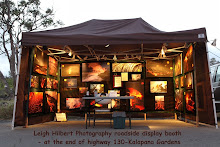
The Hawaii County lava viewing area is actually a pretty nice show, particularly after nightfall. I took the images below from the viewing road last night after closing up my lava photo display booth down there (I don’t often get the time to set it up these days)
Click on the images to see the stars & Milky Way better ;)A silhouetted home in Kalapana Gardens with lava colors reflected up into the plumes from along the ocean entries just a short ways south.

Thursday, August 5, 2010

~ The man from Montana and Pele ~


Just as in the past when lava has overtaken a community there are many stories to be told by those who endured the experience; as Kalapana Gardens residents are presently facing; this is one such story:

He envisioned a thriving goat farm on his twenty-three acres of barren pahoehoe in Kalapana Gardens but had constructed nothing yet. André Kaukane (the name he chose for this story) is from Montana and wanted to try a new direction in his life with his partner, so why not start it at the base of an active volcano in Hawaii?

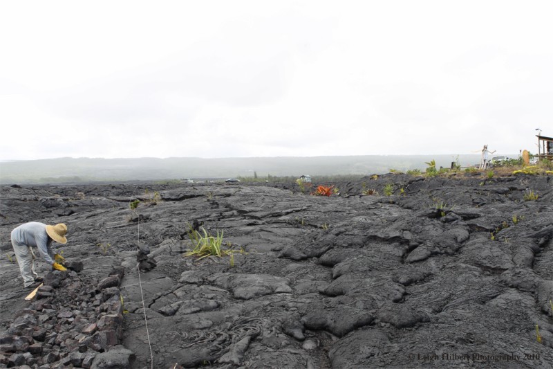
André, whose property borders Gary Sleik’s twenty-one acres, had just witnessed his neighbors home engulfed by lava and burned to the ground just a few days before I found him building a rock wall with chunks of the 1990 lava that his entire property is composed of. (Click on any of the photos for a larger view window)André had located his eastern property line and tied a string across the lavascape for a long distance, then gathered some rock-busting tools: large sledge, gloves and o-o pry-bar, and began constructing a sort-of-Hawaiian-style rock wall next to the string line. When I first came across him and his project over a week ago, André’s wall was a mere mishmash of broken rocks and he was trying to pry a large piece of lava from the ground; sweat pouring down his face. I had just walked from the leading edges of the advancing lava, which, at its closest point, was then only 250 feet west of where André was starting his rock wall.

As he gestured out across a vast area of smoldering lava fields and scorched trees, André told me most of his land was already covered by this new lava flow and he thought maybe he could help protect his nearest neighbors’ homes that lay just east of his land -- if there was a rock wall built. André had heard Hawaiian stories of rock walls diverting Pele the Volcano Goddess; either physically or by Pele’s respect for the wall, so he strongly felt he wanted to do this.
After watching André at his task for a short time I decided to help him for a little while, if simply to show the man from Montana some easier ways to fracture and remove pahoehoe slabs for wall making.

I returned to that area again three days ago, during my survey of the coastal flats lava flow, I once again found Kaukane hard a work on his lava rock wall. This time some sections actually resembled a wall. We spoke for a while as he worked or paused for a drink of water in the hot sun. Molten lava was now less than seventy-feet away to the west and was swelling with inflation and breaking out - advancing toward his wall and the two homes a short distance beyond his property line of string and rock.

André did not appear the least bit daunted by this rapid approach of lava as we talked story and he busted rock, carrying it to the newly forming wall. Just five hundred feet southeast of where we stood was his closest neighbor Lava Dave’s large family home. We could see Lava Dave’s tall slender figure standing between the hot lava fields to the west and his home; gazing out at the red-hot pahoehoe advancing his way.

I left André to his noble task and hiked across the lavascape to Dave. Dave looked stressed as he stared at red-orange lava moving a short distance before him. Dave said he was making plans to evacuate his home and had friends with trucks ready to help in the move with just a phone call. He asked me how much time I though he had before this lava would reach his home. I told him 48-hours if the rate of advancement was enhanced by strong inflation, but within a week if it slows down from deflation. After all, this lava flow had just covered nearly a square-mile or so of all the land west of his home in only one week; including his friend Gary’s place. The lava was now only 200-feet from his house and only 15-feet from some vehicles parked on his property. The prospects did not look good for Lava Dave’s huge home.So as Lava Dave and I are talking, André Kaukane walks up and joins in. André can see Dave’s duress and tells Dave that maybe a rock wall needs to be started in front of his home. Dave had hardly replied when André hikes back to his wall project, gathers all his wall-making tools and returns and begins a new lava rock wall along his stringed property line, which also borders very close Lava Dave’s home. The heat of the molten lava is so close to this line it can be felt as André begins construction… As he places the 1st stones André sincerely says to Dave & I, “I think a wall right here might divert the lava”. Dave and I look at each other and I say quietly to him, “Well, symbolically anyway”.

That massive and advancing lava flow continued its march east that night getting as close as 130-feet from Lava Dave’s home but by morning had stopped -- at the foot of André’s ‘walls’, at both locations, and has not moved an inch further since…

Wednesday, August 4, 2010

~ Cooling things down loco style ~ Lava inflation still strong ~

Sweet south swell rolling in this morning so I snapped ten-minutes of wave riders at 10:30 this morning... wishing I had jumped in with them... (Click on any image for a larger view size)

Short post today; I'm on the run:
Surfs up and lava inflation is up but not yet causing any breakouts around Kalapana Gardens that I know of--- ocean entry is strong though, which is very good because it is sucking a lot of lava pressure off the coastal flats and into the sea.

Okay, a few more south-swell shots:


Tuesday, August 3, 2010

~ Nine days later: Where Gary’s home stood ~ Ocean entry lava relieving threat to homes ~

Lava fumes and heat continue wafting from the aftermath of where Gary Sleik’s beautiful handcrafted home and gardens stood for five years until molten pahoehoe claimed it all just nine days ago.

Photos and captions below tell the grim story: images from just before lava consumed his property and photos I took of the same site yesterday---
Gary's neighbor helps prepare for possible evacuation as lava approaches his home on three sides July 24th, 2010

Below: Same location August 2nd, 2010 -- only a burned roof and water catchment canopy frame remains embedded on the still smoldering lava

Below: Gary's beautiful arbor and entrance to one of many gardens; in this shot, Gary's home has already burned to the ground and it is the fire from that which is illuminating the fence. A setting full moon through the arbor in the west- July 25th, 2010 at around 5:30 AM. Below is what remains now of the arbor: dangling tin cans to ward off garden-eating birds continues to tinkle in the wind

(Above) Here we see remnants of Gary's little forest gazebo in the foreground and his burned roof in the distance. Below: I slept next to that gazebo the night of July 23rd as lava was spreading towards the area through the forest only 100-feet away; you can see the lava in the forest in the background. Methane explosions are what disturbed my sleep. Gary was sleeping in the bedroom of his house and before retiring there he told me I was his alarm, "If I hear you screaming when lava reaches you out there, I will know it's time to get up"... I love Gary's sense of humor, even under such dire personal challenges as this event was for him.

Molten lava and brush fires approach the Gazebo July 23rd and 24th, 2010


We had carried this table from Gary's home the day lava was getting close to it; this is where we sat and watched his home ignited by lava at 3:16 AM and burn for two hours on July 25th, 2010. You can see his burned roof in the background. This sitting area has not been touched by recent lava -yet- but is now surrounded by recent expansions and uplift inflation.
You can read the blog post for this event here

Report from Kalapana Gardens

From all reports I could gather this morning about Kalapana Gardens surface lava conditions, I am told there has been no further molten outbreaks along the eastern or northern edges of the hot zone near homes as of 10:00 AM today. D/I-Inflation has continued fairly strong through the night and into this morning, which can translate into inflated coastal flat lava and stronger ocean entries. The more established the ocean entry lava becomes, the more likely that further inland breakouts will stall or completely stagnate. Pele calls the shots regardless what we may predict or hope for…

Public viewing remains open; phone Hawaii Civil Defense lava-hotline for current updates on that: 961-8093

Monday, August 2, 2010

~ Threatened homes still stand - deflation and ocean entrys helped ~

I am writing from Kalapana Gardens, from a friend's home, these homes above are a part of his view after sunset last night.

Below: Ocean entry coastline at 5:30 AMI hiked around the entire coastal flats lava plain, including the two ocean entry’s. The western most entry runs a great distance along the coast and continues spreading.

Above: most active ocean entry area with river breakouts like this in places.

The most western coastal ocean entry; the new benches are getting quite large in some sections. In this image you can see where recent lava started dripping over the pali then stopped - leaving rock-drips ;)

For those that know the old Fisherman's Road that intersected old 137 from the side of 130, well that road is still intact for about 300-feet on the makai end. The ocean entry lava has spread down the coast to the blowhole right next to the end of fisherman’s road.

And speaking of fisherman-- This guy below found one very hot fishing spot!!

... And speaking of 130 & 137, there is still pavement there at what was the turn but molten lava is breaking out across that and will consume it by days end.

I went by the three houses that I had circled in my previous post as being 'imminently threatened' by advancing lava; and at that time they truly were. But Pele gave them a break and has not advanced much further; good thing too, two of the homes had molten lava within 100-feet of them. The lava in front of their homes is still very hot and looked to be still inflating a little.

And speaking of inflating, the Kilauea deformation monitors have registered strong inflation since 10:00 AM yesterday, but that appears to be leveling off right now... Continued inflation could possibly re-energize the flow-front near the Kalapana Gardens homes. The ocean entry lava flows are now relieving the coastal flats of some of the insulated and stored lava, further reducing the advance near the community.

Sunday, August 1, 2010

~ Two Kalapana homes in imminent danger from lava ~ End of highway 130 closed ~ USGS aerials/thermals ~

The USGS/HVO personnel have done an excellent job of documenting this Kalapana lava flow from the air using both still photos and thermal imagery. Mahalo Nui to them for the tremendous effort of getting such good photos, doing thermal overlays and offering these to the public. Click on the photos to see their larger sizes for easier viewing.
I was hiking many of the leading edges of the flow fronts, including late yesterday. I have taken the liberty of placing notations on their images based on my findings on the ground, including the lava advancing very near to two residences (These are rough notations only).
You can view the original aerials with their captions on the USGS/HVO images web page by clicking on the highlighted text here.


Some temporarily reprieve from the coastal lava advance at this time may come from the continued drop in magma reservoir pressure beneath Kilauea as reflected by USGS/Hawaii Volcanoes Observatory’s sensitive deformation monitors.
Typically: a rise in pressure (D/I-Inflation) = more lava movement within the Halema’uma’u pit vent, accompanying earth tremors, and more active advancement of lava throughout the eruptive system supplying lava to the Pu’u O’o Crater and its adjacent network of tubes, shields and surface flows; from mountain to sea. A drop in magma chamber pressures (D/I-Deflation) = a lessoning of eruptive lava movement throughout the entire network: more earth tremors, a reduction of molten lava breakouts along the lava tubes coming down the Pulama Pali, a lowering of surface flow front inflation and breakouts like those that are presently threatening the Kalapana vicinity, and weaker ocean entry lava flow.

Public lava viewing closed - yesterday - but open today:
Hawai`i County Viewing Area status can be found at 961-8093

Yesterday the entire west end of highway 130, which leads to the Kalapana Gardens access roads and the Hawaii County public lava viewing area, was closed to all but local resident traffic, Civil Defense, emergency vehicles and Janguard security personnel.

This closure was deemed necessary by Civil Defense after a meeting on 130 with local Kalapana Gardens property owners and various other interests. Some expressed frustrations about sightseers trespassing on private and State lands at all hours of the day and night. Others voiced the safety concerns of having literally thousands of visitors walking all over the rough roadways and adjacent lands at night. Also, homeowners on the lava affected area may need to evacuate at any time in the days ahead, requiring a public-free, un-cluttered evacuation route in and out of the community.

The road access off the end of highway 130 is being screened by both Janguard security (hired by the county to oversee public lava viewing), as well as police at times. The entrance gate into Kalapana Gardens subdivision has also been padlocked by order of Civil Defense. These access restrictions may remain, or be lifted at any time. But for now there is zero public access or lava viewing on the end of highway 130. The ocean entry steam plumes can be seen from other nearby vantage points such as the western end of highway 137.

(And thanks for your suggestions and links in helping me to solve my computer crash problem... I am operating on a temporary fix for now... but hope to do a complete fix soon, mahalo for your help with this!),
~~~ Leigh